Light rain chances remain in place in Pittsburgh with highest chance coming in the afternoon
This cold stretch of weather that has been in place for the past couple of days isn't going anywhere anytime soon. Right now, the data shows only one day where we may get back to the average temperature for this time of the year, and that would come on Monday.
WEATHER LINKS:
Current Conditions | School Closings & Delays | Submit Your Weather Photos
Today's weather will be similar to what we have seen over the past couple of days.
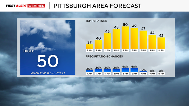
Temperatures are slightly cooler this morning, but I expect highs to still be near 50.
Frost advisories were issued for places south of I-70 where skies were expected to clear overnight. These are also communities where they hadn't seen their first widespread frost yet. Meanwhile, rain showers tracked through places north of I-80 overnight, and that is where the best chance for rain will remain in place through the end of the day.
For places south of I-80, the best chance for rain will come from noon through 6 p.m. Similar to what we saw yesterday. Winds will also continue to calm, coming in out of the west at around 10 mph.
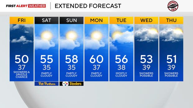
The rest of the weekend is looking pretty good for this time of the year.
I have Saturday highs hitting the mid-50s. Temperatures should hit the upper 50s for highs on Sunday. There are several big football games this weekend, including homecoming weekend for WVU in Morgantown.
It's a night game, with temperatures likely dipping to the 40s before kickoff. Earlier in the day, Pittsburgh will play at home with a 3:30 kickoff. Temperatures for the Pitt game should be in the low 50s.
Skies for both games will be partly cloudy, so that'll help it feel a bit more comfy.
Sunday's big game is also a night game with the Steelers game kicking off at 8:20 p.m. The Packers are in town, and the weather shouldn't play much of a role in deciding who wins. Temperatures will be in the low 50s as the game kicks off.
Looking ahead, model data is struggling a bit with our rain (and even some wet snow) chances for next week. It does appear we will see a powerful trough and our first real nor'easter (did the one two weeks ago meet criteria?) of the season expected to develop.
Rain chances will be a little wacky at times next week, with some days potentially seeing rain moving from the east to the west. Model data continues to show at least a chance for some snow in higher elevations a couple of times next week and the week after that.
At this point, I expect a report or two coming in on Thursday for a mix of rain and snow from somewhere in the Laurel Highlands.
Stay up to date with the KDKA Mobile App – which you can download here!