Pittsburgh temperatures warm up on Thursday before a storm system with wind, rain, and snow
Thursday morning begins with temperatures below freezing as skies have cleared out across our area through the overnight and early morning hours, accompanied by light winds.
WEATHER LINKS:
Current Conditions | School Closings & Delays | Submit Your Weather Photos
Watch out for any icy spots that may be in place as a result of melting snow and lingering water that may have frozen through the overnight hours. High pressure is located along the East Coast this morning, while a strengthening low-pressure system moves into the Dakotas this morning.
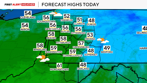
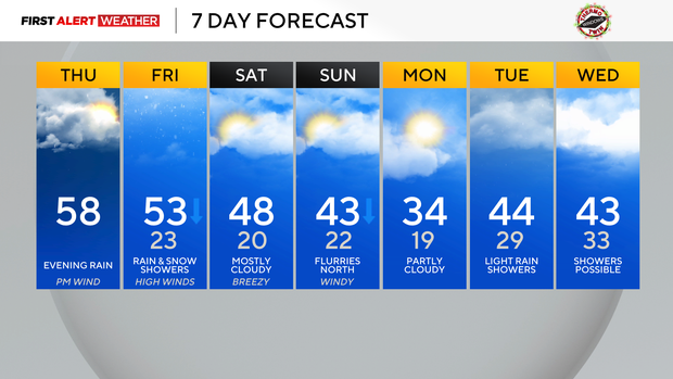
The tightening pressure gradient between these two systems will result in increasing winds through the afternoon and evening hours. Today's winds will be southerly and increasing to around 15-20 mph, resulting in air temperatures reaching the mid-50s to near 60 degrees.
Skies will be mostly clear this morning, then become mostly cloudy shortly after noon and through the evening.
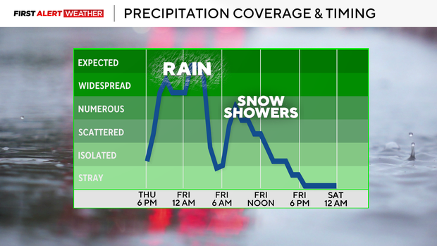
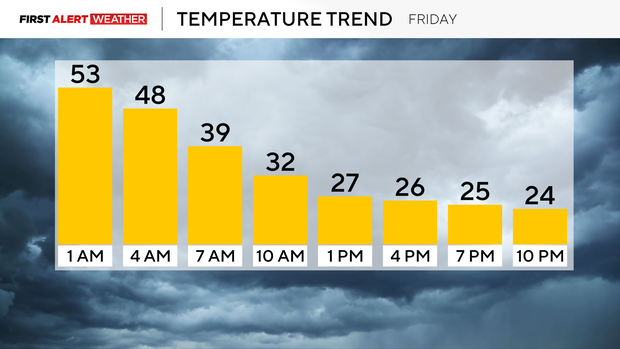
Light, prefrontal rain showers will start to move in after 6 p.m. and then increase in coverage as the evening progresses. A line of heavier rain and possibly an embedded thunderstorm will move in between midnight to just after 4 a.m. This will be associated with the cold front. Winds will shift from the south to the west early tomorrow morning, and temperatures will quickly fall from the 50s and remain in the lower 30s and upper 20s for most of the day.
Bands of snow showers are also expected to move in after 7 a.m. and persist into the mid-afternoon and evening hours. Total rainfall amounts will be upwards of 0.5" in spots with localized areas up to 0.75".
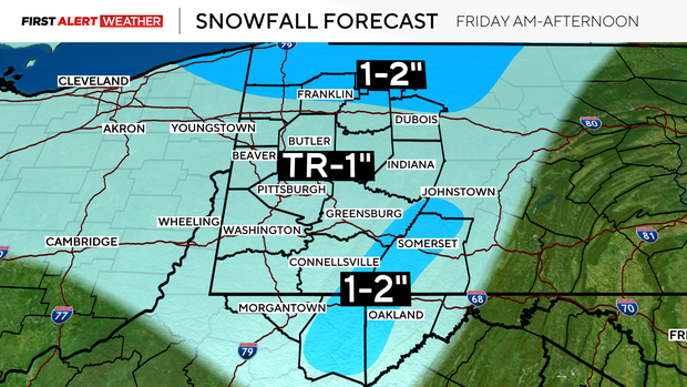
Snowfall amounts will be light for a good portion of our area as well, with most locations receiving a dusting to less than 1". 1-2" is possible on the westward-facing slopes/peaks of the Laurel Highlands and locations along and north of I-80 downwind of Lake Erie. Winds will gust upwards of 40-55 mph across our area tomorrow, with the highest gusts in the Laurel Highlands and Ridges.
This may cause minor damage to trees and power lines, so be on the lookout for that.
Cold temperatures will settle Friday night into Saturday morning as winds diminish amid high pressure moving into the area. This brief surge of cold air will not last long as relatively warmer air starts to move in on Saturday ahead of another front and low pressure that will move in Saturday night into Sunday.
A few light rain showers and snow flurries are possible with this system. Windy conditions are likely to ensue Sunday afternoon and evening as well.
Early next week will start cold behind Sunday's frontal passage, but milder air accompanied by lots of clouds and some light precipitation is expected to move in leading up to Christmas Eve.
Stay up to date with the KDKA Mobile App – which you can download here!