Spotty showers and storms possible this weekend in Pittsburgh as temperatures climb

This morning will be the coolest morning most of our region experiences for at least the next 7 days as we begin to enter a warmer stretch of weather that has been well-forecasted for our region.
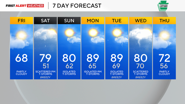
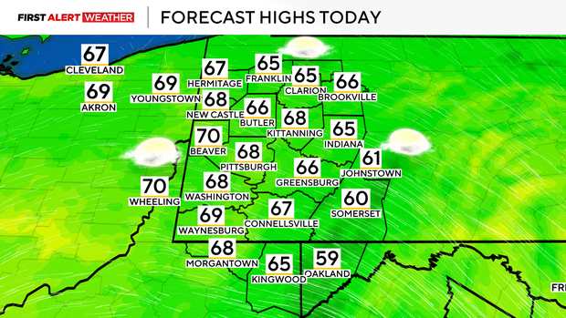
Today will be seasonable with high temperatures for most locations reaching the mid to upper 60s. Skies are clear this morning, but some mid/high-level moisture moving in during the afternoon will result in some clouds later today.
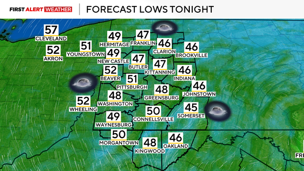
Those clouds will clear out overnight, and with dry air still in place, morning low temperatures on Saturday will be in the upper 40s to low 50s.
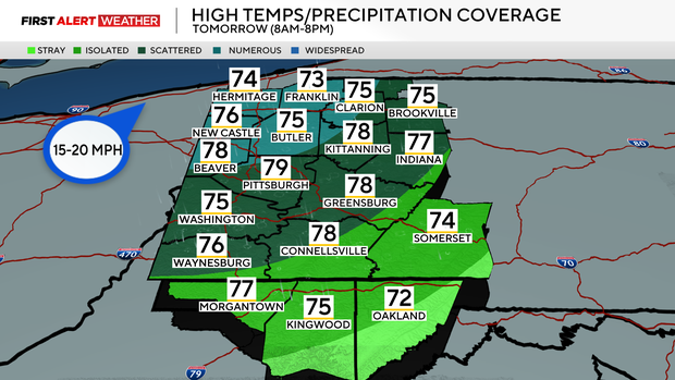
Deeper moisture will spread between 11 a.m. and 2 p.m. on Saturday, along with warmer air thanks to a west-southwest wind across the Upper Ohio Valley.
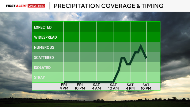
Some isolated to widely scattered showers may accompany this initial surge of atmospheric moisture, mainly from the Pittsburgh metro and points northwest. These initial showers will likely not be very strong and may even weaken due to the dry air ahead of them.
The better chance of seeing scattered to numerous showers and storms will occur between 6-11 pm tomorrow evening with a stronger disturbance and areas especially from the Pittsburgh metro and points northwest having the overall best chance.
Saturday night into Sunday will feature lows in the 60s with some residual scattered showers, then on Sunday, a warm front will move across the region with a low chance of isolated thunderstorms. Despite the warm front passing through and increased moisture, clouds should keep most spots generally in the lower 80s.
The hottest temperatures of the next 7 days will be next Monday and Tuesday as a ridge of high pressure strengthens to our southeast. Right now, I am forecasting high temperatures to be just shy of 90 degrees due to moisture in the air and the potential of some clouds, but some of our southernmost counties, especially into Northern West Virginia, will likely see a 90-degree reading or two.
The next cold front with scattered showers and storms will move in on Wednesday. This doesn't look like a severe weather setup at the moment, but we'll monitor in case of any changes in the coming days.