Temperatures in the Pittsburgh area will be slightly below average for the start of the week

Temperatures will be slightly below average to kick off the week in the Pittsburgh area.
Any Alert Days Ahead? None
Aware: This week is the last week with sunsets after 8 p.m. for the year.
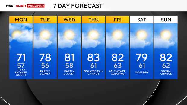
When it comes to your forecast, temperatures will remain at or slightly below average through Wednesday, with near-average temperatures in place for the rest of the week. The average high for this time of year is 81°.
The warmest day of the next seven days will likely be on Thursday. I have highs on Thursday at 83°.
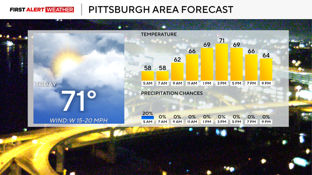
Today will likely be the coolest of the week with highs just at around 71°.
Humidity levels will remain low through the week, meaning it's a fantastic time to turn off the air conditioning if you have it and to open up the windows. It's also probably a good time to start taking allergy medicine with hay fever season right around the corner.
There is a rain chance today for our region, but for the rest of the day it is just for places north of I-80, where they'll be cloudy all day long. The upper low that continues to spin right on top of Toronto will slide to the east on Tuesday, taking our rain chances down for Wednesday.
Our next system in the way of another upper low will spin in on Thursday and stick around through the weekend.
Rain chances will be highest to the north of Pittsburgh as the system slowly rolls to the east.
August may the wettest on record in Pittsburgh
By now you probably know my stance on records. It doesn't matter what the record is. It can be for hot weather. It can be for cold weather. It can be for total snow. If we are going to get near a record, I am all for smashing right through it. We may as well at that point, right? The one issue sometimes when it comes to breaking records is that there is a real-life impact when records are broken. Attics flood. Roads wash out. Homes leak, and ground slides and shifts as we deal with saturated soils. Through 4 a.m. this morning, Pittsburgh sits just 0.35" away from setting the all-time record for wettest August ever. We have an entire week to get there.
As it stands right now, you'd have to go all the way back to 1994 to find the last time we have seen an August as wet as the one we are currently in. Amazingly, while we have seen plenty of rain this month, we have not seen widespread flooding issues across W. Pennsylvania. The same cannot be said for parts of West Virginia, where historic rain has also been occurring throughout the month. Parts of Ohio and Indiana have also been really impacted by rain over the past month.
Looking ahead, long-range model data I'd give us around a 50-50 shot of seeing the 0.35" of rain that would put this month as the wettest on record. Just looking at data, a collection of the GFS, EURO, and ensembles of both of those models along with the Canadian ensemble, the EURO is showing just around a quarter of an inch of rain and is pretty consistent overall. The GFS, as expected, is the wettest, showing around a half inch falling through next Monday. The Canadian ensemble shows right at 0.35" of rain. Of course it would.


