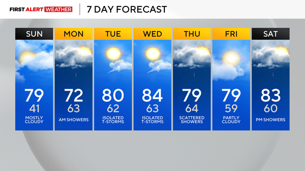
Warmer weather returns to Pittsburgh on Sunday as temperatures reach near 80 degrees
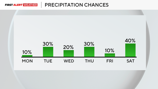
The warmer weather is back today with highs near 80 and mostly sunny skies. Overnight, our lows will be in the 60s, and rain showers will arrive tomorrow around 7 and 8 a.m.
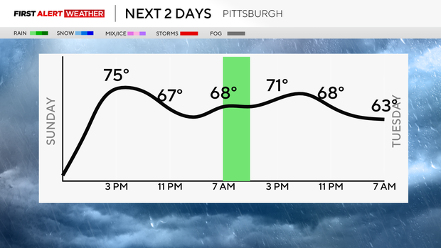
Those will continue through late morning, but it's not going to be a washout. Winds will be picking up tomorrow in the afternoon, around 20-30mph, and then the unsettled weather trend takes over Tuesday evening after some early morning showers.
All week long, we will see lows in the 60s and highs near 80 or in the low 80s, which is nearly 20 degrees above normal. Winds pick up again Tuesday late afternoon and early evening with gusts around 30-40mph for some areas and isolated thunderstorms.
Practices on Tuesday evening could get cancelled, especially with the threat of thunderstorms.
Our warmest day will be Wednesday with highs in the mid 80s, flirting with another 143-year-old record of 85° set back in 1883. Isolated storms are possible once again, so stay weather aware.
Thursday, there's another chance for showers, nothing severe, and highs again in the upper 70s. Friday, we are dry and partly cloudy with highs near 80 again.
Saturday right now looks like we hold onto the low 80s with showers possible in the afternoon/evening before cooling back down to the 60s on Sunday.
The above-normal temperature trend is expected to continue through April 25th.