Storm chances will be in place for the Pittsburgh area today

Storm chances will be in the forecast today for the Pittsburgh area, with additional severe weather possible later in the week.
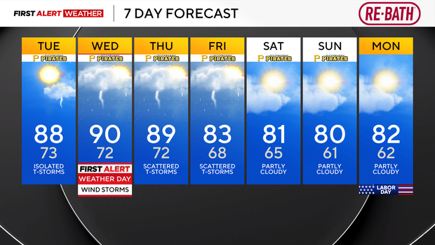
Any Alert Days Ahead? Wednesday is a First Alert Weather Day due to storm chances with strong wind speeds being the biggest concern. Tornado risk exists.
Storm chances return to the area today, sticking around through Friday. I am just going to prepare you now; there are going to be a lot of people each day that sees nothing. Let's take today as an example.
Across KD country, our northern half is under a slight, level 2 out of 5 (5 being highest) risk of severe storms today. The rest of the area is under a level 1, marginal risk. I fully expect most won't see a drop of rain today, but the atmosphere is energized, and anything that develops will have a chance to become severe very quickly.
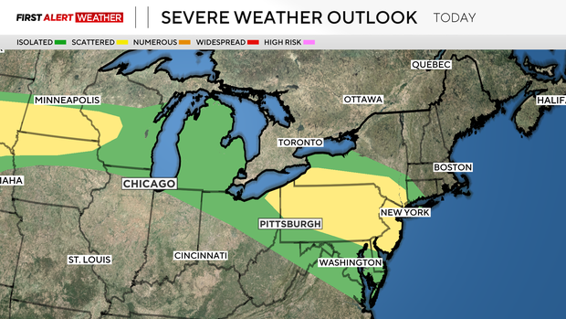
Strong destructive winds are the main concern. I have today's coverage percentage coming in at 40 percent, but that is probably too high.
Our highest storm chances will come on Thursday and Friday morning. Wednesday storm chances will also be higher than today's chance. The forecast is a tough one, because we are on the edge of the 'heat dome' that national media loves to talk about. This ridge of high pressure is pushing temperatures to near-record highs in many places. Pittsburgh's record high for today is 97°, so we won't be anywhere near that. I have us hitting 88 degrees for the daily high, with noon temperatures in the mid 80s already.
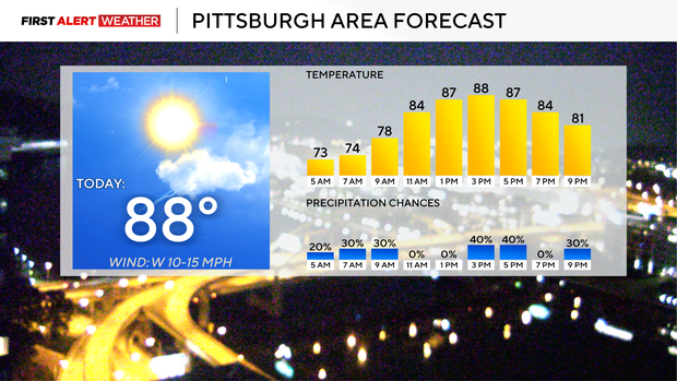
It will also be humid with dew points near 70° all day. Winds will be out of the southwest at around 10 mph.
Getting back to storm chances, with our current weather setup of hot weather to the southwest battling with a fairly progressive upper system entrenched over Eastern Canada and pushing cooler air all the way down into the Great Lakes, New York, and eastern parts of Pennsylvania, we have conditions that are ripe for strong storm development. A fairly vigorous upper jet will add to instability, with any waves from the upper jet potentially triggering wind storms that could race through with speeds of up to 80 mph. This set-up is a literal line of dominoes that once one falls, everything else will quickly fall, with only a stable layer of air helping to hold back storms. It's a complicated dance that will continue to occur until Friday, when we finally see the ridge breaking down and temperatures returning to near normal.
So storm chances will be around, with a lot of dry time and really hot weather in place. I have highs hitting 90 degrees on Wednesday and 89° on Thursday. Friday highs will likely return to the mid-to-low 80s, with Labor Day temperatures near 80 degrees.
Just quickly want to put the wrap on a near record-setting month of August, where our final rain total of 7.62 inches was just 0.24" shy of the record for the month of August. That total was 4.1" above the average for the month and was the highest since 1994 (7.75"). Our average temperature finished just 0.5° warmer than average with a daily average temperature of 72.3°.


