Historic snowstorm hits Pittsburgh area, with snow to continue through Sunday night
The big, accumulating snows are exiting the Pittsburgh area. While we will see occasional snow showers, accumulations will not be anything like the record-setting snow on Sunday.
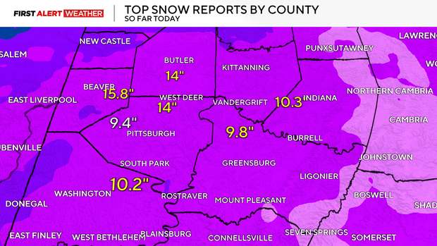
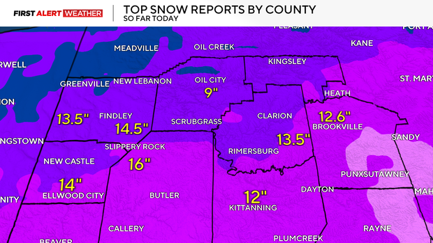
After Pittsburgh saw a record-setting 11.2 inches of accumulation and 10 to 20 inches in many parts of the region, we will need some quiet skies to clean up.
Here's the latest forecast and storm timeline for the Pittsburgh area.
How much snow is expected in Pittsburgh?
Most of the area was expected to see around 12 inches of snow, with some areas like the ridges of Fayette and Westmoreland counties forecast to have additional accumulating snow on Monday.
As of 9:30 p.m., more than 11 inches of snow had been recorded at Pittsburgh International Airport.
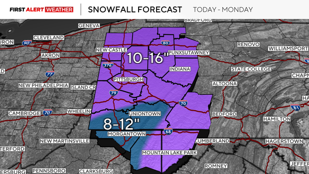
Snow will continue to snow through 10 p.m. on Sunday, with some counties seeing snow accumulating through Monday morning.
Table shows hourly snowfall rates in Pittsburgh
The National Weather Service shared a table that breaks down the hourly snowfall rates across the Pittsburgh region.
The light snow in the early morning hours is expected to pick up around 10 a.m., with many cities expected to see snowfall rates of 1 inch per hour through 2 p.m.
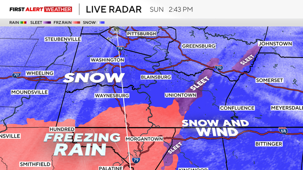
Sleet concerns in western Pennsylvania
While snow was the main concern Sunday, as a warm sliver of air worked its way in, some counties saw periods of sleet.
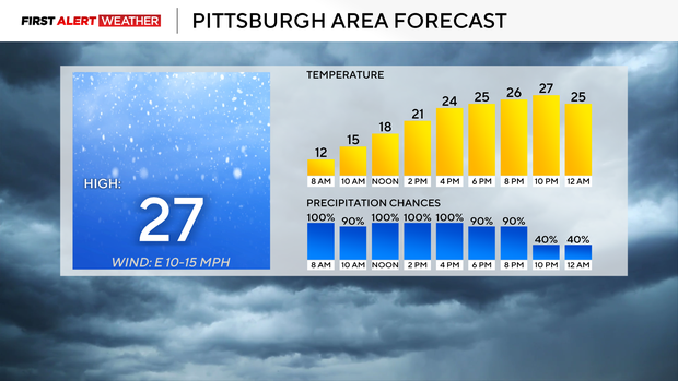
How cold is it in Pittsburgh?
Highs will hit the upper 20s due to a late-day push of temperatures ahead of an Arctic front that drops on Sunday night.
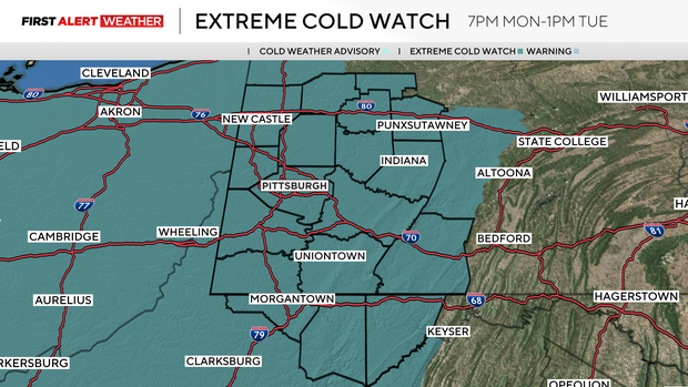
Extremely cold temperatures are likely on Monday and Tuesday. The National Weather Service has issued an extreme cold watch for the area from 7 p.m. Monday until 7 p.m. Tuesday.
Sunday's snowfall sets single-day record
According to the National Weather Service Pittsburgh, the record snowfall for Pittsburgh on Jan. 25 was set in 2014 when 5.2 inches fell. As of 9:25 a.m. on Sunday, that record was broken.
Multiple counties have reported upwards of a foot of snow today across western Pennsylvania.
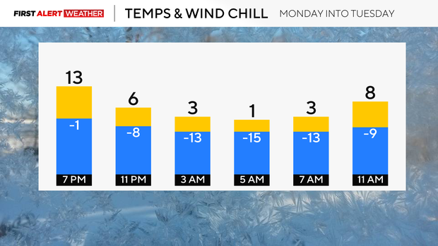
Frigid temperatures follow snowstorm
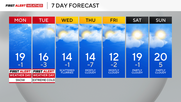
The rest of Monday will be frigid with temperatures dipping to the teens for the afternoon and bottoming out near 0 degrees just before midnight on Tuesday. Tuesday morning lows will fall to minus-2 degrees with wind chills of minus-10 to minus-20 below zero.
The rest of the week, the KDKA Weather Team has highs hitting the teens with morning lows at or below 0 degrees every day. The weather will be extreme and dangerous, with frostbite potentially setting in as little as 30 minutes for those who are not properly prepared for it.
The frigid feel to the weather will be hard to shake. The sub-freezing week ahead will keep the snowpack in place. This snowpack will also act as a refrigerant to keep the temperatures down.
That said, it is going to be clean-up time for the region. It is Pennsylvania law that you make reasonable efforts to clear off your vehicles before driving. This is supposed to be done within 24 hours of the storm ending.
When shoveling, take it easy. The extremely cold temperatures are tough on your body, so make sure to take frequent breaks while digging out.
WEATHER LINKS:
Current Conditions | School Closings & Delays | Submit Your Weather Photos