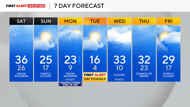
Saturday starts with snow, but tapers off in Pittsburgh as temperatures fall through the day
Today, some woke up with 1-2" of snow, and that will taper off late morning.
WEATHER LINKS:
Current Conditions | School Closings & Delays | Submit Your Weather Photos
More snow showers will be around later today in the Laurel Highlands and ridges, as well as some counties to the northeast, where another 1-2" is possible. Our high temperatures will be near normal in the upper 30s and fall during the afternoon as a cold front passes.
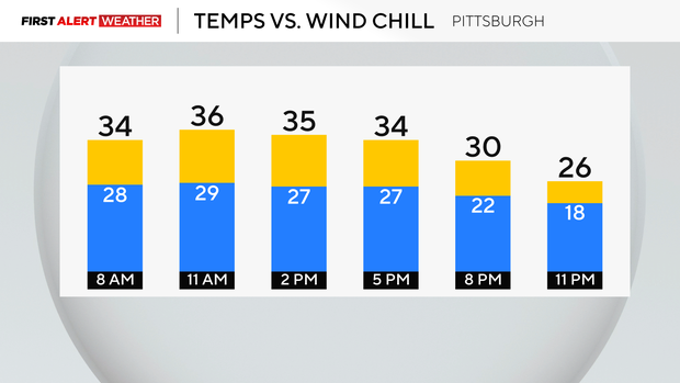
Hourly Conditions:
- 9 a.m.: 33° Cloudy
- Noon: 36° Cloudy
- 3 p.m.: 35° Cloudy
- 6 p.m.: 33° Cloudy
Sunday will be partly cloudy with temperatures only in the 20s all day. Snow showers return overnight Sunday and last through Monday afternoon. These quick bursts of snow will drop a quick 1-2", leaving slick roadways.
On Monday, our highs stay in the 20s with single-digit lows and feeling even colder and below zero with gusts around 30-40mph.
Tuesday will be even colder with lows in the teens and single-digit wind chills by Tuesday morning. It will be dry but bundled up when you're out and about, and remember, if it's too cold for you, it's too cold for your pets!
Our highs get back to the 30s mid-week.
Stay up to date with the KDKA Mobile App – which you can download here!