Pittsburgh to get some afternoon snow on Wednesday ahead of possible storm this weekend
There is also a chance for snow on Wednesday, but it isn't anything like what we are expecting on Sunday.
Snow possible on Wednesday
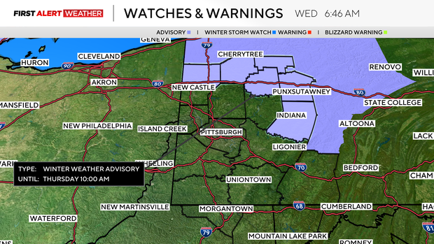
Places north of I-80 should expect to see an additional three to five inches of snow on the ground by the time the sun comes up on Thursday morning. Fresh snow in Pittsburgh will likely be minor, with snowfall amounts near 2.5". On the ground, snow will not stick around for long.
We may see briefly a half inch of snow or so, but that will be it for places south of I-80. The best chance for seeing a rain & snow mix comes for those south of I-70.
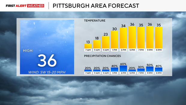
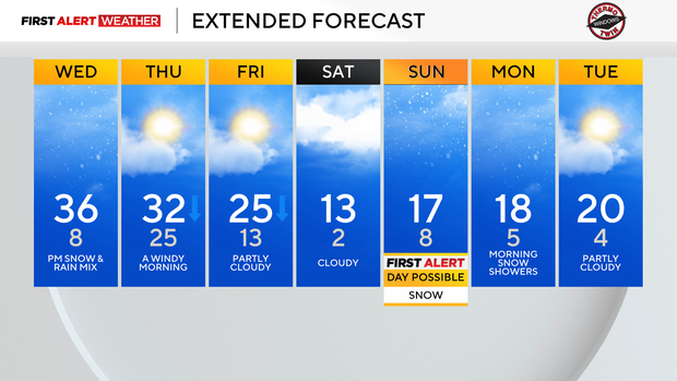
Highs today will hit the mid-30s with falling temperatures throughout the day on Thursday and Friday. Thursday highs, hit at midnight, will be near 32 degrees.
Friday midnight temps will be in the mid 20s and should be the daily high as well. Cold weather is back over the weekend, with Saturday lows bottoming out at around 2 degrees. I have single-digit morning lows occurring on Sunday, Monday, and Tuesday, too. When it comes to weekend highs, Sunday is the warmer of the two with a high of around 17 degrees.
Big snow event forming this weekend
You need to start preparing, especially if you are in Pittsburgh to the south, for a possible big snow event occurring Saturday evening into Sunday.
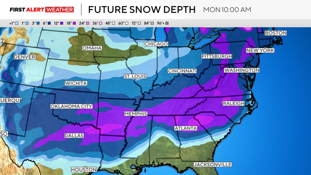
At this point, someone is going to get a lot of snow dumped on them. The only question is where the track is set up with the heaviest snow.
Right now, the deformation zone looks to be just south of our region, setting up along and just south of I-68. This is going to be a monster storm, though, with wrap-around precipitation stretching as much as 250 miles north of the center of rotation. This puts most of western Pennsylvania in an area with snow totals of around 3 inches to 8 inches of snow being expected.
There is still plenty of time for things to change. At this point, this storm is going to bring big snow totals to a lot of people, though.
Historically, model bias five days out for winter storms has been to push the track too far south. With model runs closer to the event, the track is to the north. I am mentioning this because at this point, it looks like snow numbers coming in right now that are already high, but could go even higher.
I'd assume at this point, there is a 45 percent chance of seeing snow totals near what model data is showing right now. Another 30 percent chance for numbers even higher than what the data is currently showing.
Finally, I'd say there is a 25 percent chance of numbers coming in less than what is being forecast at this time. Finally, let's get to temperatures and your forecast.
Stay up to date with the KDKA Mobile App – which you can download here!