Storms bring multiple tornado warnings to western Pennsylvania

Multiple tornado warnings were scattered across western Pennsylvania on Tuesday evening.
The National Weather Service issued tornado warnings for parts of Butler, Lawrence, Forest, Clarion, Venango and Jefferson counties between 7 p.m. and 8:15 p.m. All the tornado warnings have since expired.
In a social media post, NWS Pittsburgh said it had video confirmation that a tornado was on the ground near Portersville, Butler County.
The original forecast story can be found below.
The National Weather Service forecast severe storms between 12 p.m. and 8 p.m. on Tuesday. A severe thunderstorm watch was in effect for Allegheny, Beaver, Fayette, Greene, Washington and Westmoreland counties, but it was canceled early.
The chance for severe storms shifted slightly south around noon. While places north of Butler, like Mercer and Venango counties, are under a slight risk, much of the area is under an "enhanced" risk for severe weather, meaning there is a higher confidence that severe storms could take place.
"Several severe storms could be significant," the NWS said, adding that "significant" is defined by wind gusts of at least 75 miles per hour, hail of at least two inches, or a tornado of at least an EF-2 category.
In addition to the hail, wind and tornado risks, the NWS has also issued a flood watch for parts of western Pennsylvania. The watch takes effect at 1 p.m. and is expected to remain in place through the evening.
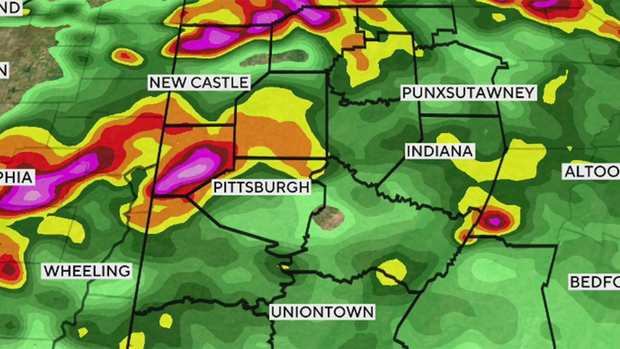
"Rainfall rates could be between 3"-5" per hour," the NWS said.
A less intense second round of storms could move through the area after 7 p.m. Tuesday.
When it comes to the forecast today, highs will be the low 80s just briefly ahead of storms. Winds will be out of the southwest at around 15mph this afternoon, with gusts possibly getting over 30 mph at times this afternoon. Skies will be partly cloudy during the morning, but mostly cloudy to overcast this afternoon.
Looking ahead, the next good chance for rain comes next Monday and Tuesday. Up until then, humidity levels will be low and high temperatures seasonal.
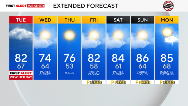
It's the type of weather where your A/C units can take a couple of days off if you so choose, with it being cool enough to stay comfy with open windows instead of A/C.


