Chicago weather live: Tornado warnings, thunderstorm warnings; ground stops at Chicago airports



The Chicago area is under an enhanced risk for severe weather Tuesday, with severe storms and a damaging derecho both in the forecast.
A Tornado Warning for Kane County until 11 a.m., Cook and DuPage counties, including Chicago, until 11:15 a.m. and for Grundy, Kankakee, Kendall and Will counties until 11:30 a.m.
If you are in the area of the tornado warning, you should seek shelter in a basement or an interior room — like a closet or bathroom — with no windows on the lowest level of your home or building.
Tornado sirens have been reported in Aurora and Plainfield around 10:15 a.m. Aurora University has instructed its students to seek shelter.
There have been reports of winds peaking at 98 mph near Plainfield as of 10:24 a.m. If you have west-facing windows, you are advised to move away from them while the storm blows through.
A Severe Thunderstorm Warning is in effect for Kane and McHenry counties until 10:45 a.m.; for Grundy, Kendall and Livingston counties in Illinois and La Porte County in Indiana until 11 a.m.; and for Cook, DuPage, Kankakee and Will counties until 11:15 a.m.
A destructive thunderstorm is expected to hit Chicago in the next half hour with 80-90 mph wind gusts.
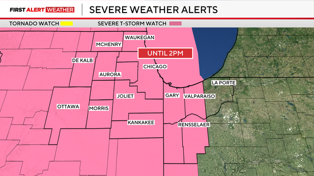
A Severe Thunderstorm Watch is in effect for LaSalle, Kane, Kankakee, Grundy, Will, Cook, DeKalb, DuPage, McHenry, Kendall, and Lake counties in Illinois and Newton, Jasper, Porter and Lake counties in Indiana until 2 p.m. and for La Porte County until 4 p.m. CDT.
A Flood Advisory has been issued for Boone, DeKalb, LaSalle, Lee, Ogle and Winnebago counties until 1:30 p.m. and Grundy, Kane and Kendall counties until 2 p.m.
There is a ground stop at Chicago O'Hare International Airport and Midway International Airport due to thunderstorms.
The main window for severe weather in the area is expected to be about 9:30 a.m. through 1:30 p.m. The greatest risks are for flooding and wind damage, as a derecho in Iowa is barreling due east toward the area and is expected to cut a path of destruction through the Chicago area and Northwest Indiana.
Wind gusts of 80 to 95 mph are possible during these storms, with more isolated gusts over 95 mph. Hurricane force wind gusts over 70 miles per hour have already been detected by doppler radar near Sycamore in DeKalb County as of 10 a.m.
The storms are expected to reach the city by about 11 a.m.
There are outflow boundaries along the central and southern lines of the storm which could produce tornado warnings as the line of squall storms reaches it.
The storms are forecast to move east-southeast through the Chicago metro and Northwest Indiana.
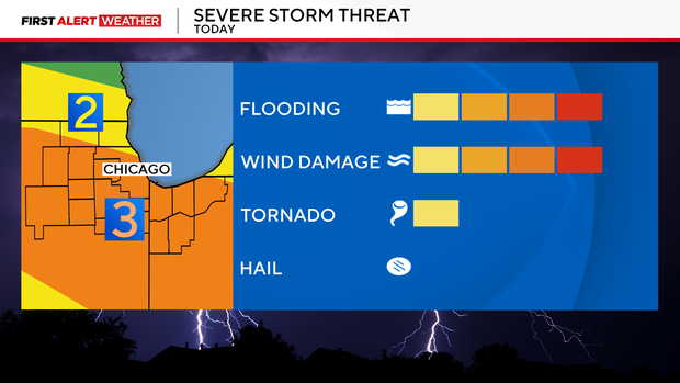
Heavy rainfall will also be a concern, especially across Chicago, which already received up to 5 inches of rain by Sunday night. Localized flooding could develop where storms repeatedly track over the same areas.
Storm activity should decrease later Tuesday afternoon into tonight, but the overall weather pattern remains active, with additional chances for thunderstorms continuing through the end of the week and into the weekend.
What is a derecho?
A derecho is defined by the National Weather Service as a complex of thunderstorms that produces a relatively unbroken line of wind damage measuring at least 240 miles in length with wind gusts at least 58 miles per hour along its path.
In 2020, a massive derecho with winds around 100 mph cut a path of devastation across the Midwest, including the Chicago area and Northwest and Central Indiana, causing an estimated $11 billion in damage. In 2009 a Super Derecho was recorded as one of the strongest on record, traveling more than 1,000 miles in 24 hours and causing $500 million in damage as well as a handful of deaths.


