Scattered snow showers with milder and drier weather ahead

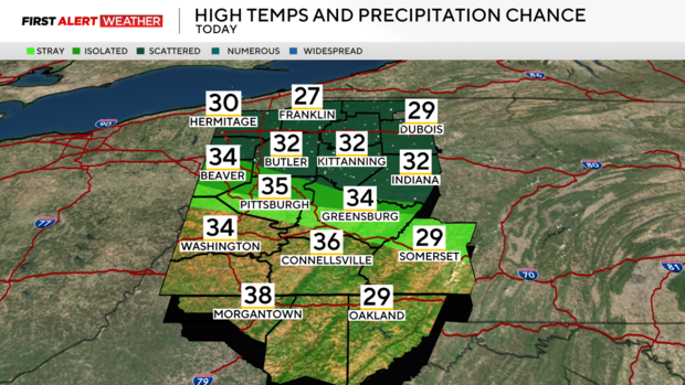
PITTSBURGH (KDKA) - Temperatures through the overnight and into the morning hours have dropped off into the teens and single digits early Saturday morning. Clouds have gradually been moving in through the overnight and into the morning hours. Southwest winds are transporting warmer air into the region, which will allow temperatures to rise into the upper 20s to low and even a few mid-30s today.
WEATHER LINKS:
Current Conditions | School Closings & Delays | Submit Your Weather Photos
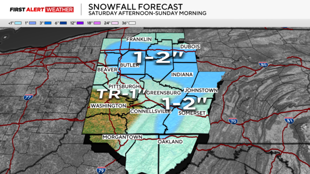
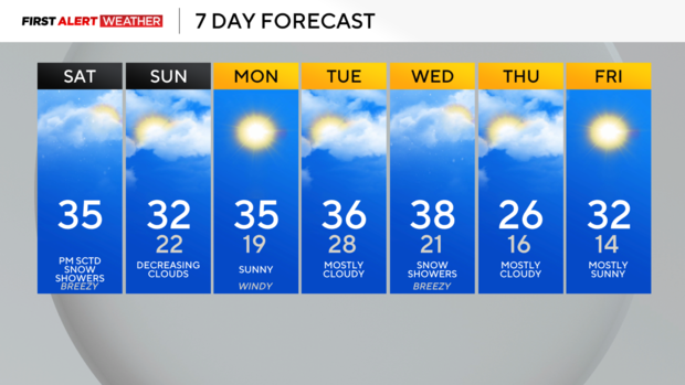
A weak and fast-moving disturbance will move across Western PA during the afternoon hours of Saturday into Saturday evening. This will bring a band of light snow showers to the northern half of our area between 2 p.m. through the late evening and overnight hours. The most likely location for this band of snow to set up will be between HWY 422 and I-80. Not all models are in agreement on the development of this band, and moisture is limited, but there is still potential for its development. Snow totals will range from a trace to locally around 2 inches in spots. Skies will begin to slowly clear on Sunday mid-day into the afternoon, with mostly sunny conditions to start next week. The sunnier conditions will also be accompanied by gusty winds as well, especially in the afternoon and evening on Monday.
Mild temperatures will stick around for the first part of next week, as we see several days of westerly wind blow into the region. Highs will reach the mid 30s next Monday through Wednesday. Another fast-moving system will approach from the northwest next Wednesday with a chance of snow, but moisture will be limited somewhat. Temperatures will likely briefly dip back to below normal levels before a more prolonged warming period takes place by the end of the month into February.
Stay up to date with the KDKA Mobile App – which you can download here!


