Saturday forecast in Pittsburgh shows weekend snowstorm could bring up to 16 inches
We are continuing to closely monitor a large and impactful winter storm that is expected to affect the Pittsburgh area and much of western Pennsylvania, and while there is still some uncertainty with exact totals and storm details, confidence continues to increase that this will be a significant snow-producing system for our region.
Arctic high pressure has settled into the region leading to calmer winds, but a very cold and dry day across western Pennsylvania with temperatures that are struggling to approach the mid-10s.
Clouds are spreading in and will continue to thicken through the evening hours as our major winter storm system approaches.
Snow has begun falling across Central Indiana into Kentucky, with echoes on radar showing up as far east as Western Ohio. Some of these echoes that show up on radar will not be snow that reaches the ground due to the dry air in place between 3,000 and 12,000 feet. This dry layer is expected to erode quickly between 7 p.m. and 12 a.m. from south to north, which will allow snow to begin.
How much snow will Pittsburgh get this weekend?
Total snowfall amounts as expected have increased with this storm system. A broad zone from roughly between the I-70 and I-80 corridors including the Pittsburgh metro is likely to receive upwards of 10-16" with locally higher amounts.
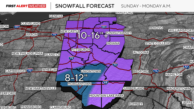
Near and south of I-70 to I-68 is where some sleet may mix in which will result in slightly lower amounts, but still a healthy 8-12".
As far as snowfall type, the majority of this will be a light, fluffy snow.
There will be a window from late morning through mid afternoon as temperatures and moisture levels increase where the snow will become a little heavier and wetter, especially from Pittsburgh and points south.
The snow will end once again dry and fluffy as the cold air moves in from the northwest behind the departing system.
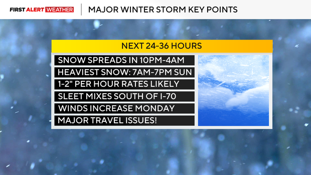
When will the snow start falling in Pittsburgh?
Our southern counties near and south of I-70 will see light snow begin first around 10 p.m.
The Pittsburgh metro will start to receive snow beginning around midnight, and it will continue to spread northeast through the night.
The heaviest rates of snow are expected to occur between 7 a.m. and 7 p.m. Sunday as lift in the upper atmosphere increases along with strong moisture flux ahead of a surface low pressure.
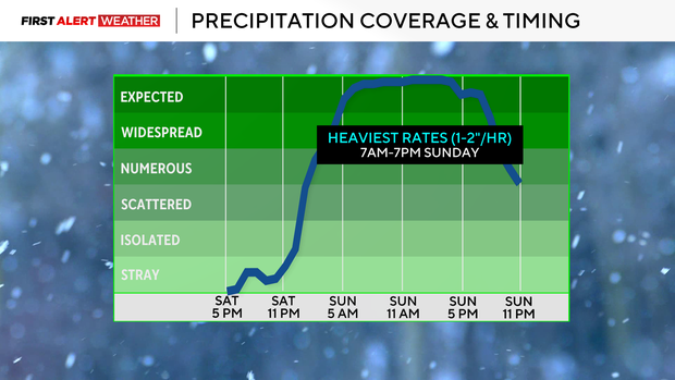
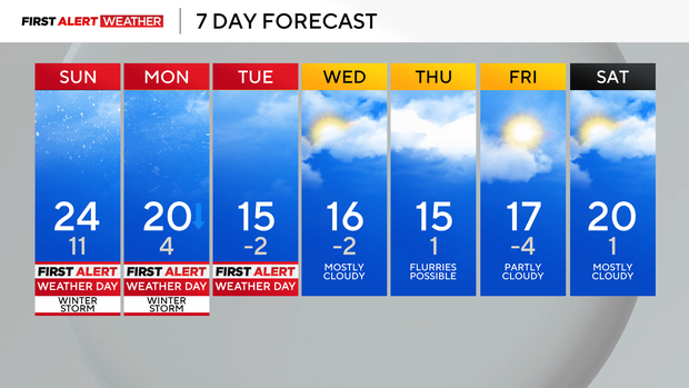
Snowfall rates will lighten after 7 p.m. Sunday, but expect off-and-on snow showers to continue Monday. These on Monday will be accompanied by gusty winds and reduced visibility. Blowing snow is likely as well, with gusts as high as 25-35 mph possible.
Travel is highly discouraged during this storm, especially from Sunday into Monday. Rates of 1-2" per hour between 7 a.m. and 7 p.m. on Monday will make it difficult for plows to keep up with this snowfall.
Some lingering flurries and snow showers are expected into Tuesday, but the middle to end of this week will be accompanied by a prolonged stretch of below normal temperatures. There will be several mornings with air temperatures in the single digits to below zero, which could lead to hazardous wind chills. Below normal temperatures are expected to continue for our area through the end of January into early February.
WEATHER LINKS:
Current Conditions | School Closings & Delays | Submit Your Weather Photos