Mild Or Wild: KDKA 2021-2022 Winter Weather Forecast
By: KDKA-TV News Staff
PITTSBURGH (KDKA) -- We've made it to November. There are just two months left in 2021, and that means snow is approaching probably sooner than most of us would like.
Every year around this time, the KDKA-TV weather team of meteorologists Ray Petelin, Ron Smiley, Kristin Emery and Mary Ours digs through the data and crunches the numbers to figure out if we're in store for a mild or wild winter.
The Transparency:
First thing's first, we know accountability is important. So we're going to tell you what went right and what went wrong with last year's Winter Weather Forecast.
We got November right, but then December happened.
A whopping 27.5" fell, making last December the second snowiest on record, and blowing our prediction out of the water. Or perhaps we should say out of the snow drift?
Our prediction was pretty close for January, but February saw twice as much snow as we were expecting.
So while the seasonal forecast obviously was off, our daily forecasts were pretty spot on, and that's why we forecast every day. So now let's focus on what's to come this year.
The Setup:
Large-scale climate patterns involving the tropical Pacific Ocean often impact our winter weather. It has to do with how warm water temperatures get.
For the second year in a row, what's called La Niña conditions have developed.
Normally, trade winds push warm surface water toward Asia.
During La Niña, trade winds are stronger than usual, pushing even cooler water to the surface. That can affect temperature and precipitation across the U.S. by modifying the jet stream's position, making it wavier and causing more storms.
Climate models show an 87% chance of the current La Niña conditions continuing through February 2021. It typically produces cooler and wetter winters for southwestern Pennsylvania and the Great Lakes region. Yet recent La Niña years have brought us warmer winters or, like last year, a mix of above and below-average months.
The Temperatures:
With the overall warming trend over the past few decades, our average temperatures have been slightly increasing. But this year, we're forecasting slightly cooler than average temperatures due to a slightly negative North Atlantic Oscillation.
With this pattern, winds from the east and northeast are more frequent, bringing colder air.
The Pacific Decadal Oscillation, which fluctuates every 20 to 30 years, also plays a role.
During a cool or negative phase, the western Pacific Ocean becomes warmer and part of the eastern Pacific Ocean cools, which also indicates below-average temperatures.
Now, when we talk about average temperatures that doesn't mean we'll stay around the normal temperature every day. We could have days five to 10 degrees warmer or cooler than average and some days a difference of only a degree. In the end, it all evens out.
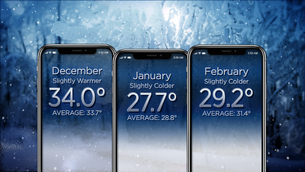
Here's how we think this winter's temperatures will pan out:
--December will end slightly warmer, at 34.0 degrees on average for the month.
--January will be slightly colder, with an average of 27.7 degrees for the month.
--February will also be slightly colder, at 29.2 degrees for the monthly average.
The Snow - Past & Present:
You know those stories that start off with "back in my day" and end up talking about snow piled over cars as people walked to school up hill both ways? We've all heard them, right?
Well, did people years ago actually see more snow back then or are we seeing more snow now?
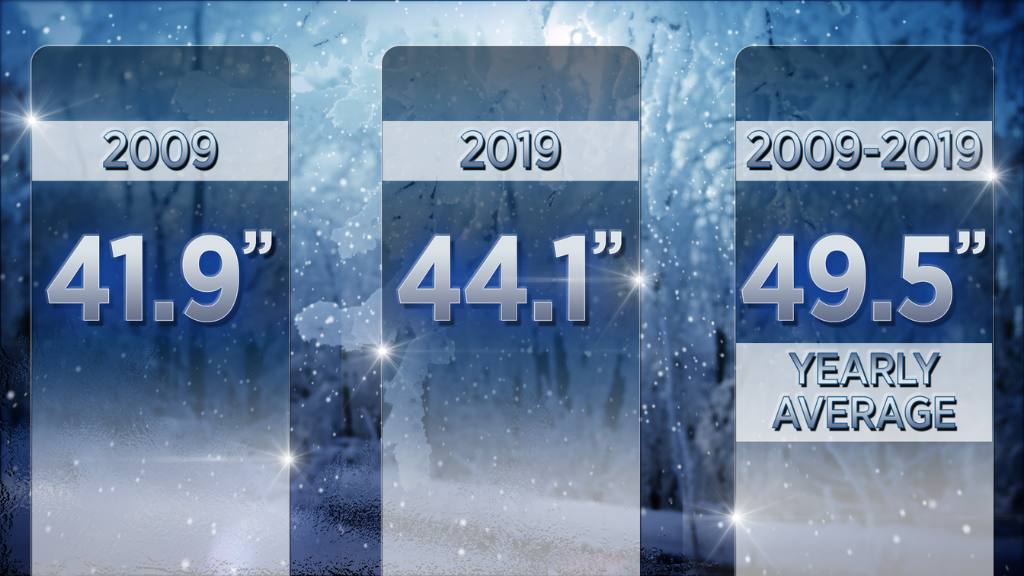
Every 10 years, the National Weather Service calculates our 30-year snowfall average. We just got the new one, and it's actually up a couple of inches. A decade ago, the average was 41.9". Currently, the average is 44.1". That's because over the last decade, Pittsburgh has averaged 49.5" of snow a year.
So let's settle the age-old debate once and for all.
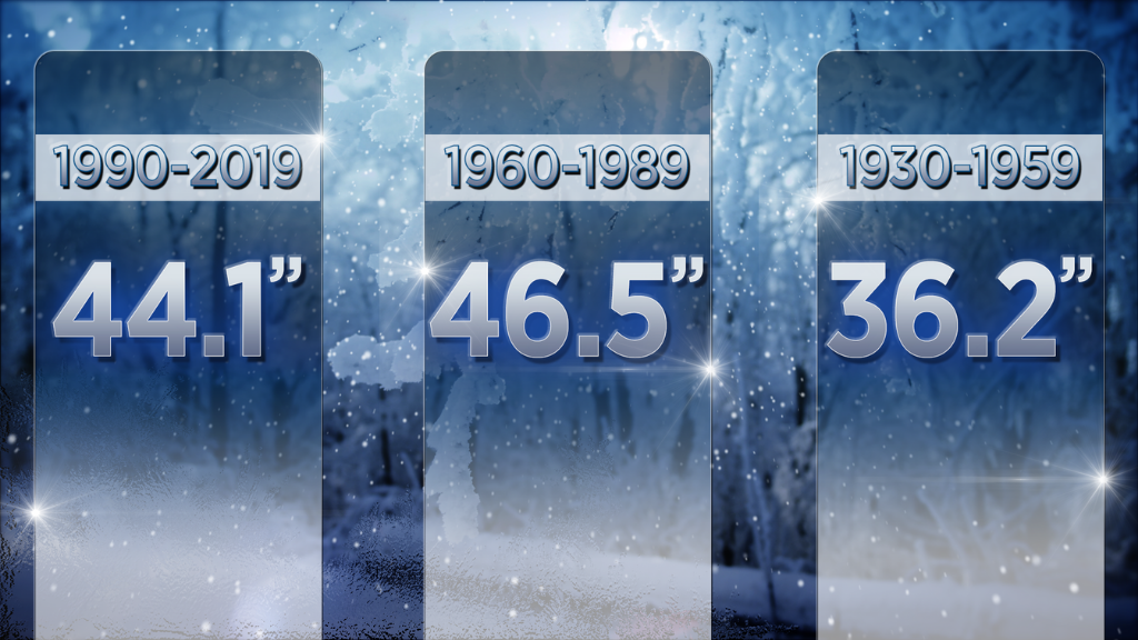
The 30-year average from 1930-1959 was 36.2". That means if you're over the age of 60, believe it or not, you saw the least amount of average snowfall a year compared to everyone younger than you.
The 30-year average from 1960-1989 was 46.5". So that means if you're in your 30s, 40s or 50s, you actually did see more snow, on average, than everyone older and younger than you.
And, finally, the 30-year average from 1990-2019 was 44.1". This means anyone under 30 has seen more snow than their grandparents, but not more than their parents.
The Snow - Future:
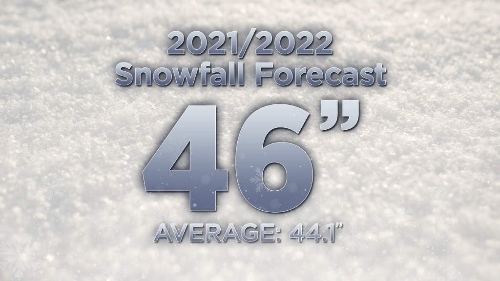
This winter we're expecting a little more snow than we usually get in a winter, but not quite the nearly 58" we got last year.
For November, we're forecasting about 2" of accumulation, which is just a tad below average.
In December, we're calling for 10", which is a little above average.
January is usually when we get the most snow, and this January is looking especially rough with 17" in the forecast.
February should be about average, with 12".
As for March and April, as the last gasps of winter hang on, we're forecasting 5" spread over both months, which is below average.
All in all, our snowfall forecast for this year is looking like a classic Pittsburgh winter with a grand total of 46", which is just a few inches above the current winter snowfall average.


