Pittsburgh will see periodic storm chances this weekend and through next week | First Alert Weather
Isolated to scattered storms are possible this evening with a crossing cold front bringing a chance for storms with damaging winds and hail.
First Alert: In effect through 8 p.m.
Aware: Very warm this coming week again.
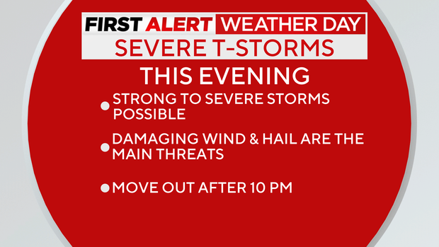
The Storm Prediction Center has placed us in a level 1 out of 5 "marginal risk" for isolated severe storms. Lingering showers should clear out overnight and in time for early Easter sunrise services.
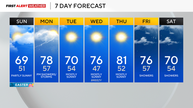
Temperatures on Easter will be in the upper 60s under partly sunny skies, so a pleasant end to the weekend is on the way!
More storms could rumble through by Monday with the next system. A stalled boundary will return to the north as a warm front Sunday night into Monday morning. Thunderstorms are likely between midnight and 8 a.m. Monday--some of which could contain some hail.
Another round of storms is possible Monday afternoon and evening ahead of a cold front. Severe weather will be possible if enough storm fuel builds up through the day, so we are monitoring for a possible First Alert Weather Day later Monday.
Following Monday's storm chance, temperatures will remain warm into the middle to end of next week with plenty of sunshine!
WEATHER LINKS:
Current Conditions | School Closings & Delays | Submit Your Weather Photos