Pittsburgh Weather: Temperatures once again near 90s on Saturday
PITTSBURGH (KDKA) - A severe thunderstorm warning has been issued for parts of Washington County until 5:45 p.m. Saturday.
Original story and full forecast below.
It's still going to be another hot one this afternoon with highs rising into the upper 80s and possibly near 90°.
WEATHER LINKS:
Current Conditions | School Closings & Delays | Submit Your Weather Photos
Humidity levels still remain low thanks to dewpoints in the 50s, so at least it'll stay comfortable and not muggy. So remember your heat precautions if you're outside for a while, and don't forget the sunscreen! UV index values today will be around a 7.
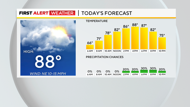
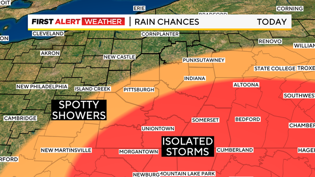
There are finally some rain chances that arrive in the afternoon. Those chances will be mainly south and east of Pittsburgh.
Given the unstable atmosphere in that region, there could be some isolated storms with quick downpours and possible thunder. We could use some rain though after a very dry May. The latest drought monitor came out Thursday, and our area is experiencing abnormally dry conditions.
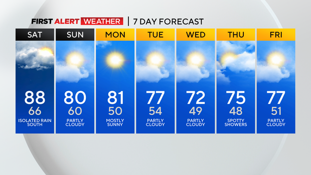
Overnight, lows only drop to the low 60s with partly cloudy skies and showers dwindling.
Starting tomorrow, our highs will lower back into the upper 70s and lower 80s! A cold front will be moving through and cool us down for many days to come.
So much more comfortable and seasonable weather for the first full week of June.
There could be some spotty showers on Monday night with this cold front. This will lead us into another dry stretch, but there could be some spotty showers east again on Thursday, but highs will be below average in the low 70s then.
So get ready for a big change-up next week!
Stay up to date with the KDKA Mobile App – which you can download here!