Pittsburgh Weather: Temperatures just around 10 degrees warmer this morning
PITTSBURGH (KDKA) - Just a heads up there are a number of small changes with the forecast with concerns about rain chances over the next week.
As of this morning, we are going to see the subtropical jet stream parking right on top of us beginning tomorrow and going through most of the next week. This will mean a couple of things but at the top of the list is uncertainty.
WEATHER LINKS:
Current Conditions | School Closings & Delays | Submit Your Weather Photos
While there aren't too many big temperature changes in my forecast they can easily change as the jet stream sweeps both north and south.
Rain chances will also be around with us at the mercy of fast-moving mid-level systems that ride the jet stream and move fast. These small impulses are oftentimes tough to forecast more than 48 hours out and even then they are sometimes missed.
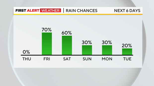
The first example of this is now the rain I expect we will see Saturday afternoon into the evening hours.
Yesterday it was looking like Saturday would be completely dry, but now it appears Saturday has the best rain chance for the next week. The fast-moving system won't drop a lot of rain (maybe a third of an inch). It will be a minor annoyance for most, but will obviously have an impact on anyone with outdoor plans.
Friday morning rain chances are also still in the forecast with maybe a fifth of an inch of rain falling. Rain totals obviously don't look very high on Friday but the entire day is going to be one of those days with some pockets of drizzle along with an occasional shower or two.
The other big change comes in the way of temperatures.
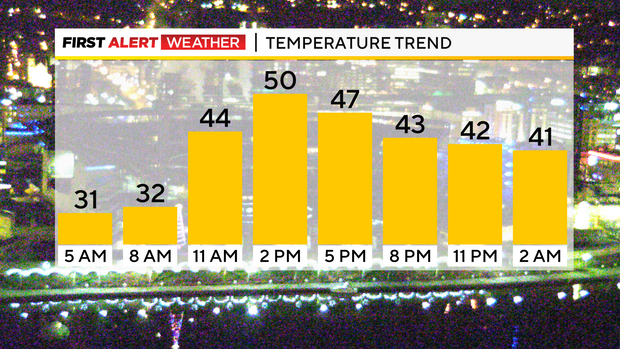
Yesterday's model guidance was too warm. I caught it and kept my temperatures in the range where I thought we were most likely to fall with the cold air in place.
I nailed the forecast with us seeing a high of 34 degrees. Model data has really bumped up highs for today though.
Yesterday I was forecasting a high in the mid-40s but today. Data is coming in showing highs in the low 50s and I have bumped up my highs to be consistent with guidance.
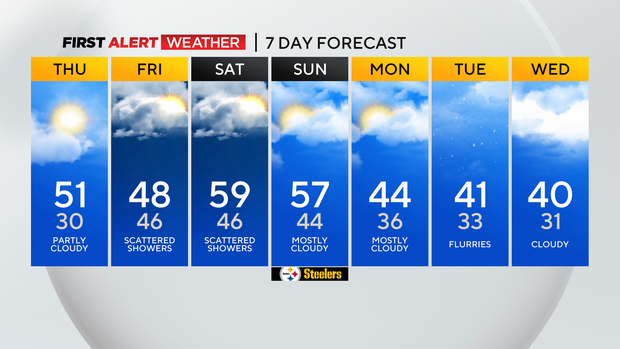
I will keep our highs in the 50s on Friday Saturday and Sunday but will drop temperatures into the mid-40s on Monday for highs.
Monday highs will be hit at midnight.
Stay up to date with the KDKA Mobile App – which you can download here!