Pittsburgh Weather: Snow and rain tag-team a chilly Tuesday

PITTSBURGH (KDKA) - Here comes the snow.
- Daily average High: 51 Low: 34
- Sunrise: 7:07 Sunset: 5:03
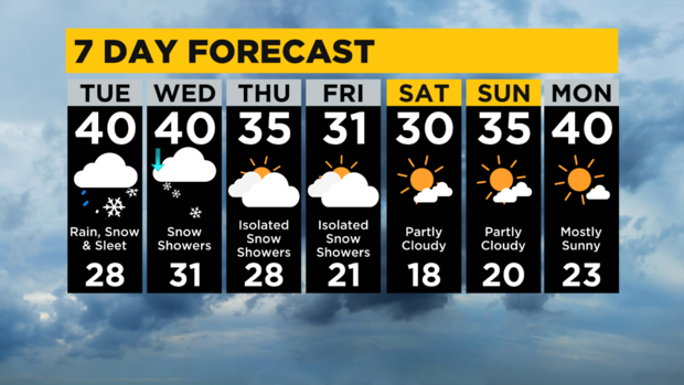
Today: There is a winter weather advisory in place for higher elevations in the Laurels. Cold with snow showers and a mix at times of snow, sleet, and rain.
Any Alert Days Ahead?: You could make the argument for today with the advisory in place and our first decent snow of the year moving in this afternoon. Also weekend chill is borderline an alert day.
Aware: Temperatures turn cold for this time of the year over the weekend.
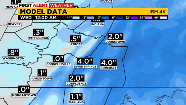
Forecasting here in Pennsylvania is always interesting because there are so many smaller climates that you must forecast for. The weather north of I-80 is going to be a lot different than the weather for places south of I-80 today. If you're in the Laurels, you may be one of the places expected to see upwards of seven inches of snow falling today. After your weekend snow, you could easily see four to five inches of snow on the ground by sunrise tomorrow.
As with all forecasts, there is always an element of uncertainty during the cold weather months when it comes to totals. We oftentimes have a level of uncertainty when it comes to where the rain-snow line will set up as well. I am saying to be prepared for whatever mother nature brings our way today. You should have a kit in your car that will allow you to survive a day or two on your own if you're traveling out of town. The time to prepare was yesterday with some pretty nasty conditions likely to be in place today through Friday.
Today, your morning will be dry and temperatures are in the 20s for this morning. Highs today will be near 40°. It looks like most should expect to start with snow showers this afternoon.
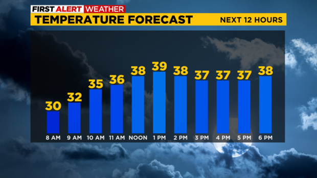
Snow begins at around 3 p.m. for Pittsburgh, around 2 p.m. for Greene County, and around 4 p.m. for places up along I-80. There will be snow, rain, and sleet mix possible through at least 6 p.m., and then as things begin to break up, we will see rain showers breaking out.
Temperatures this evening should remain around 40° through around 2 a.m. on Wednesday. Winds will then change and it appears snow showers will start blowing in from the west again. Temperatures should rapidly drop to near 32 with decent snow showers for elevated heights. Snow numbers of 4-5 inches on the ground will be possible over the next 24 hours in some spots in the Laurels. Pittsburgh's totals should be less than an inch. No matter what we see, Pittsburgh's snow won't be on the ground for long.
Looking ahead, there are lower snow chances for the rest of Wednesday, Thursday, and Friday. Cold weather then moves in for the weekend with weekend highs in just the low 30s. I have Wednesday and Thursday highs in the mid-30s.
WEATHER LINKS:
Current Conditions | School Closings & Delays | Submit Your Weather Photos


