Pittsburgh Weather: Air quality improves overnight after Code Orange Day issued for area

PITTSBURGH (KDKA) -- An air quality alert is in place for the area through 4 p.m., but conditions have improved overnight already.
Any Alert Days Ahead? No.
Aware: Best chance to hit the 90-degree mark this week comes on Thursday.
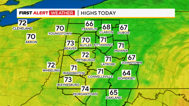
The average high this time of the year is 82 degrees. We should be slightly over that today for highs. I have Pittsburgh hitting 86 degrees for today's high after hitting 85 yesterday.
We are right on the edge of a nasty 'dome of heat' that will send temperatures in the midwest into triple digits. This dome will actually keep our weather fairly quiet this week with our best chance for rain happening on Thursday as the dome pushes east.
Rain will be possible on Thursday morning, giving way to the hottest weather of the week occurring that afternoon and Friday. I have highs both days hitting the upper 80s but data behind the numbers hints at 90s certainly being possible both days.
Getting back to today's weather, there is an air quality alert in place through 4 p.m. today. The good news is air quality has improved and all but one reporting sensor is showing either green or yellow conditions. Green means 'good' air quality. Yellow means 'moderate' air quality.
While fine ozone particulates have improved, the other concern would be with Ozone levels. There's additional good news there with clouds already in place, ozone formation should be low and I don't think our air quality will drop into the orange 'hazardous to sensitive groups' range.
Our weather week, as with most of the country will be impacted the most by the massive 'heat dome' of high pressure in the center of the country. The dome is centered over the Midwest with places like Dallas, Kansas City, & Sioux Falls will see highs near 100 degrees.
Parts of Indiana and Kentucky will also be flirting with highs in triple digits this afternoon and for much of the week. Our highs today will be in the mid-80s due to cloud cover. What we call a backdoor cold front moves in from the northeast this afternoon into tomorrow morning. This will bring highs down to the low 80s on both Tuesday and Wednesday.
The hottest days of the week will be Thursday and Friday with highs up near 90 on both days.
There is a chance for rain as the warmer air moves in with the best chance for rain this week coming in on Wednesday evening to Thursday morning. Cooler air is pegged to roll in for the weekend.
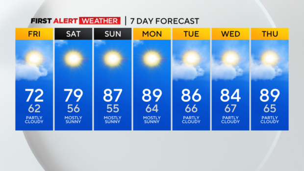
Right now the chance for rain on both Saturday and Sunday is low.
WEATHER LINKS:
Current Conditions | School Closings & Delays | Submit Your Weather Photos