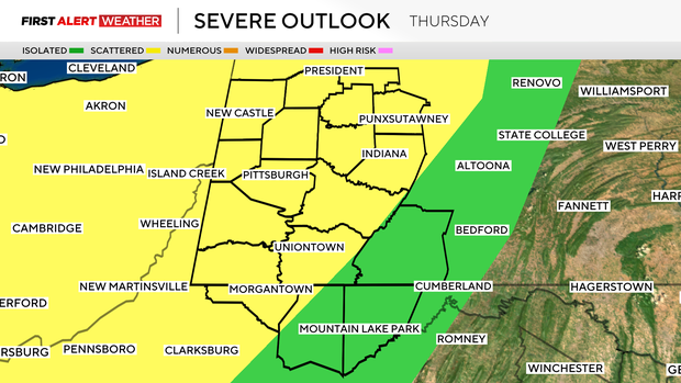
Severe thunderstorm watch issued for counties north of Pittsburgh
After severe weather killed three people and knocked out power to hundreds of thousands of people on Tuesday, the Pittsburgh area is bracing for another round of storms.
A severe thunderstorm watch was in effect for several northern counties, but it has since been canceled. A watch is in place for several counties, including Indiana, Somerset and Westmoreland counties until 11 p.m.
Temperatures are climbing Thursday afternoon, thanks to a warm front moving through our region. This warmth is also being accompanied by an increase in moisture which will lead to some instability ahead of the chance for showers and storms.
What time will Pittsburgh see storms?
Isolated development is possible as early as 2 to 3 p.m. along the warm front, but the area will likely see the best chance for more numerous storms after 5 to 6 p.m. through midnight.
What are the main threats?
Out of the numerous storms that will be on the radar, a few could turn severe with downburst winds up to 60 mph being the main threat, along with hail ranging from as small as peas to as large as half dollars.
The tornado threat remains low due to the potential of moisture mixing out late in the day and high cloud bases, but there is still an isolated potential in the northwest counties where there may be a little more moisture and low level spin, allowing some storms to rotate.
Pittsburgh could see more storms Friday
The overall storm threat winds down after midnight with cloudy skies expected to continue into the morning Friday with some isolated rain showers or drizzle. Winds will shift to the southwest Friday afternoon, allowing some warmer and dry air to move, leading to some clearing skies.
A cold front associated with this storm system will move in from the northwest, sparking off some more thunderstorm development beginning in Ohio with activity moving southeast into Western Pennsylvania by as early as 4 p.m. Coverage will be isolated to scattered, so not everyone will see a storm, but any of the storms that do form could contain damaging wind gusts.
Each day next week comes with some chance for rain and storms
The cold front that moves in Friday into Friday night will stall over the area this weekend. A second low pressure system will then move in from the west on Saturday and as of now, most models are showing this low to stall and meander to the west for the entire weekend and into the middle of next week.
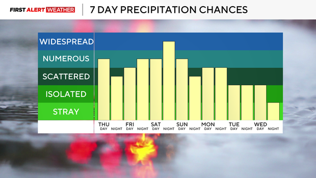
Meteorologists call this a cutoff low because the system will be removed from the jet stream and be forced to spin around until something picks it up and carries it away. This will mean every day has the chance of some showers and storms. While it won't rain at all times over the next week, each day will likely have a chance for some rain and storms until the large scale pattern shifts, likely next Thursday or Friday.