Pittsburgh in for a rainy day as run off from Hurricane Isaias moves through the region

Rain from the broad area of low pressure from post-tropical Isaias continues to move through this morning. Rain totals have not disappointed, with radar-estimated rain showing a fairly broad area of communities seeing around an inch of rain.
There is a little discrepancy between what radar estimates are showing and actual rain totals being measured. Currently, through 5 a.m., the Pittsburgh airport is showing 0.61" of rain has fallen. The 4 a.m. hour saw the largest hourly total with 0.16" of rain falling. As expected, the heaviest rain of this event will occur from 3 a.m. through around 10 a.m., with hourly rain rates of around a fifth of an inch certainly possible.
This event remains mostly a rain event with little to no storm activity expected.
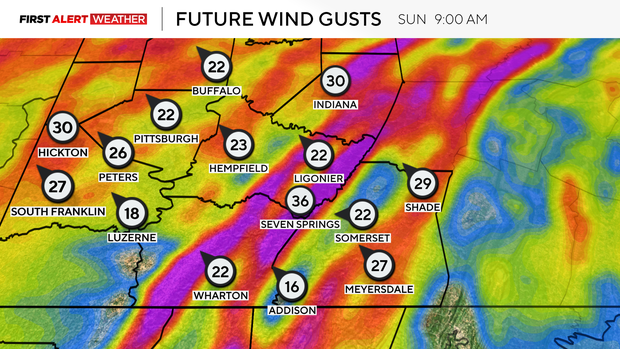
While we do have the wind advisory in place through 2 p.m., wind speeds aren't too impressive right now in most places, with Oakland, MD (37 mph) being the only place showing winds gusting stronger than 20 mph. Contour imagery does show those strong wind gusts stretching into parts of Somerset and Fayette County.
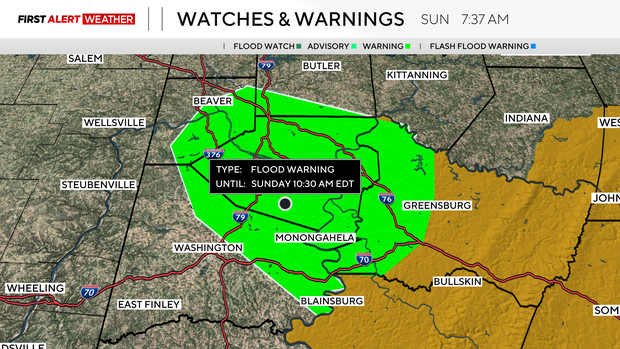
A Flood Warning is in place through 10:30 a.m. for all of Allegheny County, and parts of Beaver, Westmoreland, and Washington counties.
The heaviest rain will continue through around 10 a.m. Rain rates will be lower through 1 p.m., with just isolated showers expected after 1 p.m.
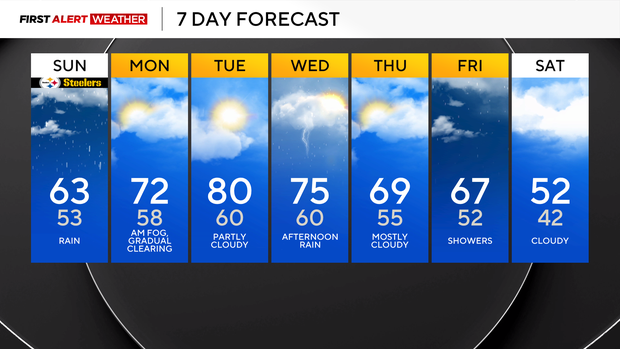
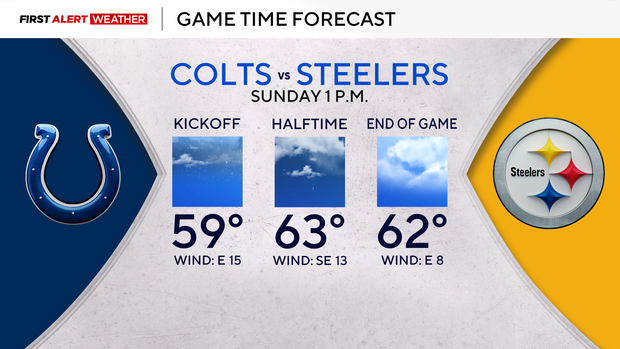
Getting into your forecast, skies will remain cloudy throughout the day. It'll be damp and windy too, even after the wind advisory comes to an end at 2 p.m. I have highs today hitting the mid to low 60s. You'll probably want long sleeves or some type of light jacket if heading to the Steelers game this afternoon. Game time temps should be in the low 60s with winds coming in from the east at around 15 mph.
The best chance for rain for the game will be at the start of the game, with the 2nd half looking dry. I can't rule out a passing shower at any time during the game.
Temperatures warm up on Monday and Tuesday, with Monday highs hitting the low 70s and a chance for us to hit the 80s on Tuesday. A cool front on Wednesday will see cooler temperatures in place for the rest of the week.
Wednesday highs will hit the mid-70s ahead of the front. Some storm activity will certainly be possible as the front comes through. Thursday and Friday highs will be in the 60s.
Another front on Friday will cool us down next weekend, with highs just in the 50s next weekend, and there's a chance some communities could dip down near freezing on Sunday morning.