Pittsburgh stays dry and sunny Wednesday, but much-needed rain moves in on Thursday
The Storm Prediction Center has painted us as having a marginal risk of severe weather on Thursday. Anytime there is a severe weather threat for our area, a lot needs to go right for storms to develop. Thursday's storm chance has a particularly high bar to clear in order for storms to develop in the afternoon.
WEATHER LINKS:
Current Conditions | School Closings & Delays | Submit Your Weather Photos
The main thing is how much instability is able to build with off-and-on rain expected all day long. At this point, it looks like the window for severe weather will be from around 5 p.m. - 9 p.m.
Thursday's rain and storm chance will come as we see a late-day cold front slide through our area. Convergence of winds at the surface ahead of the front will be enough to also cause lift and mostly rain showers to spread through the area.
This could begin as early as 4 in the morning. Not trying to get too complicated, but there's also a separate rain chance this evening through around 2 a.m. tomorrow. This is isolated with places south of I-70 seeing the best chance for rain.
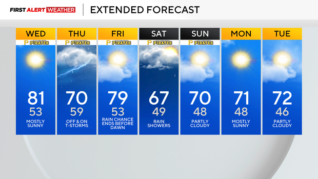
In today's forecast, today will be the hottest day of the past week and is expected to be the hottest of the next week too. I have highs hitting 81 today for the high. Skies should be sunny!

As the sun is going down, we will see a brief isolated rain chance as a short wave rolls through. I have the chance for rain 'highest' from 8 this evening to 2 a.m. on Thursday morning. Rain and storms are more directly related to the cold front after 4 a.m. on Thursday.
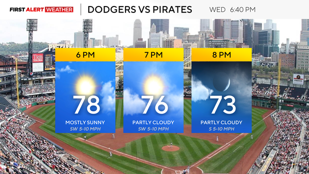
Noon temperatures today will be in the mid to upper 70s with sunny skies. Winds will be out of the south at around 5mph. Humidity levels will slowly tick up today into tomorrow morning and will be fuel for any severe storms that impact our area on Thursday.
Back to Thursday's rain, the later in the day we go, the higher the chance for rain as the lift increases. It's the breaks we will be watching the closest, as the hotter we get, the more instability is built with the cold air in place in the mid-levels. This will act as fuel as the cold front comes through.
I have dropped our temperatures to the low 70s on Thursday, and if that's our high, our storm chances will remain in the low stage. If we see a big enough break in the rain tomorrow, where temperatures soar to near 80, then our severe weather chances will also soar.
Strong winds along with an isolated tornado are the biggest concerns for tomorrow when it comes to severe weather.
Stay up to date with the KDKA Mobile App – which you can download here!