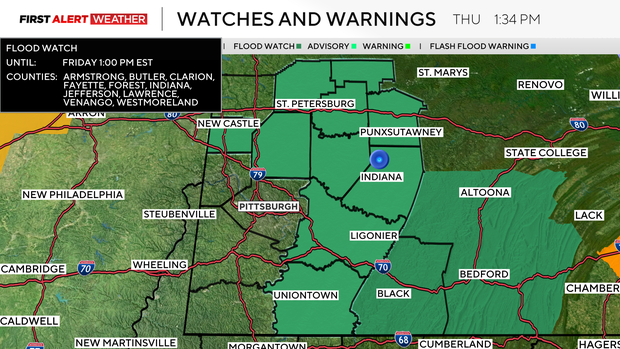
Multiple Pittsburgh-area counties under flood watch as ice jams and rain cause concern
A flood watch is in place for several western Pennsylvania counties until Friday afternoon as rain and higher temperatures could lead to ice jam flooding.
The watch covers Armstrong, Butler, Clarion, Fayette, Forest, Indiana, Jefferson, Lawrence, Venango and Westmoreland counties until 1 p.m. Friday.
Ice jams could raise water levels quickly
The snow depth for Pittsburgh officially hit zero at 7 a.m., the National Weather Service said, making it the first time since Jan. 14 that there hasn't been a measurable snow pack or a trace.
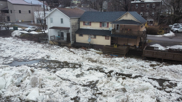
But the warmer temperatures come with the threat of flooding. The NWS said the Youghiogheny and the Allegheny rivers may see some ice movement over the coming days. Ice jam flooding comes with little warning, the NWS said, and people near rivers and creeks are reminded to stay vigilant.
The North Sewickley Township Police Department alerted residents just before noon on Thursday about rising water levels, advising people who live along the Connoquenessing Creek to evacuate. Nearby, the New Sewickley Fire District warned people in Marion Township of rising water levels due to ice jams.
In Butler County, officials are just asking people to keep an eye on the water and be prepared.
Butler County Emergency Management Specialist Amy Marree says when water rises beneath frozen sheets like these, they can pile up downstream, blocking the channel and forcing water out of its banks with little warning. And once that happens, roads can disappear fast.
"With the combination of recent rainfall and warming temperatures, this has caused ice to fracture obviously, and with the ice moving, causing some damming if you will, it's causing the waters to rise at levels more rapidly than they normally would," Marree said.
Marree said the biggest mistake residents make is waiting too long. Once water surrounds a home or covers a roadway, emergency crews may not be able to safely reach you, especially if ice prevents rescue boats from launching. That's why crews are urging families now to make a plan.
"Be vigilant and watch those water levels," Marree said. "If they're going to rise rapidly, then you need to take action. You need to get yourself safe."
Emergency officials said they'll be monitoring the Connoquenessing Creek around the clock Thursday night.
Emlenton Fire Department warns of flood risk
The Emlenton Fire Department in Venango County has warned residents of a flood risk due to ice jams.
According to the fire department, a potentially dangerous ice jam formed in the borough overnight on Thursday, and the water in the Allegheny River has risen "significantly."
They said that if residents hear a prolonged blast of the town fire siren, it will be an indicator of rapidly changing conditions and a notice to evacuate the areas near the river.
Those locations include anyone adjacent to the river, River Avenue, Honeysuckle Road, and some camps and houses along Riverview Drive.
When will the rain arrive?
Scattered showers are forming in advance of a warm front, which will move towards the Pittsburgh metro around Thursday evening. A more widespread and potent wave of rain and thunderstorms arrives overnight into Friday morning.
While states west could see severe storms, the intensity is expected to diminish as they head toward Pennsylvania. Despite that, some non-severe thunderstorms and pockets of heavy rain are still likely between 11 p.m. to 6 a.m. Friday.
Most areas will receive around half an inch, but with training storms, some isolated 1 to 1.5 inches are possible, which could lead to localized flooding.
As the cold front with this strong area of low pressure moves east during the midday to early afternoon hours of Friday, isolated thunderstorms can't be ruled out between 10 a.m. to 1 p.m. There is a very low-end potential that anything could turn strong to severe.
Falling temperatures and gusty winds will occur behind the boundary with gusts upwards of 40 to 50 mph through the evening. Some wrap-around rain mixed with snow showers is possible tomorrow evening for areas near and north of I-80.