Some people in the Pittsburgh area could see snow today, kicking off an active weather week
Some people in the Pittsburgh area could see snow today, kicking off an active weather week for western Pennsylvania.
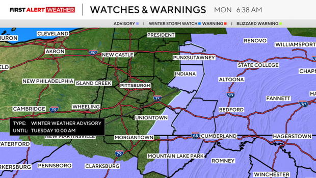
Any Alert Days Ahead? There is still a chance Tuesday could end up a First Alert Weather Day due to freezing rain. Advisories are now posted for high elevations and Indiana County, where a tenth of an inch of ice accretion will be possible.
Aware: Winter weather advisories are in place through 10 a.m. on Tuesday morning.
This week is looking like an active weather week with snow, rain, freezing rain, and thunderstorms all expected over the next seven days. Some days we may see multiple things happening within just a few hours. Welcome to March.
Pittsburgh will be dry today, but not everyone will be. Accumulating snow is expected for places south of I-70 with snow falling through the early afternoon hours. What falls will be significant in these communities with most places seeing around 2" to 3" of snow. What sticks will be much smaller, though, with areas outside the ridges and Laurel Highlands likely seeing less than an inch of snow accumulation.
Snow is expected to fall through around 2 this afternoon with temperatures remaining below 32° all the way up to at least 11 this morning.
Winter weather advisories are now up for tonight with freezing rain expected. For Indiana County, the Ridges of Westmoreland and Fayette Counties, and the Laurel Highlands, the advisory goes from 10 p.m. today through 10 a.m. on Tuesday. Everyone is expected to get light rain and showers on Tuesday morning. The question is how cold temperatures will drop to? I have most places outside of the Laurel Highlands and Ridges seeing temperatures right at or just above 32°. It doesn't mean that temperatures in a place or two won't fall low enough for slick conditions. It just doesn't look like it will be widespread.
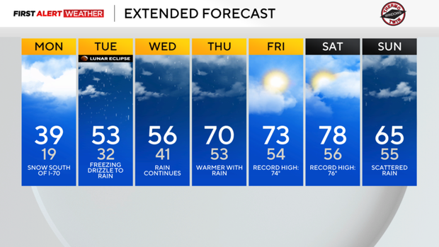
Rain chances stay fairly high through Thursday with on-and-off rain and even a storm or two possible. Temperatures will warm up though with highs in the mid-50s on Wednesday. Temperatures will be in the 70s on Thursday through Saturday. We may see record highs on Friday (Record high: 74°) and Saturday (Record high: 76°).