Rain is expected today for the Pittsburgh area, followed by cooler temperatures

Rain is in the forecast today for the Pittsburgh area, followed by a drop in temperatures.
The most widespread rain is expected from the morning hours through 2 p.m. Thursday. Temperatures will then fall gradually below normal levels.
This November has been unseasonably warm and dry so far. To date this is the 8th warmest November on record with a mean temperature of 54.1 degrees. Much cooler air is expected to move in over the next few days following the passage of an area of low pressure and cold front across our area. Rain is developing and becoming widespread with this system.
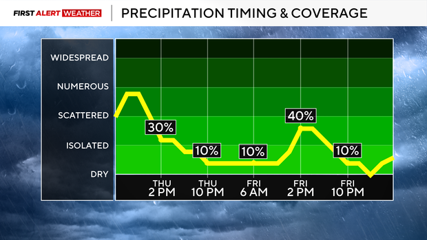
The most widespread rain will occur from sunrise through early afternoon with most areas receiving 0.25-0.5".
There will be a dry slot later this evening and overnight with less widespread precipitation as the surface low moves east of the region. However, winds are expected to increase out of the northwest which will transport in some cooler air across the region. Temperatures by midnight will fall to near 40 before ending up in the mid 30s Friday morning. During the late morning-early afternoon hours of Friday, scattered area of lake-effect showers will develop and affect especially the northern and western portions of our forecast area. While surface temperatures will be in the upper 30s to low 40s, very cold air aloft will allow a few snowflakes to mix in. A more organized band of lake-effect showers mixed with snow is likely to develop Friday night into Saturday morning as the low-level steering winds become aligned favoring flow off of Huron and Erie.
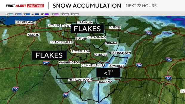
Snowfall accumulations will be minimal for most of our area with a trace to dusting at best. Up to 1" is possible in some of the peaks of the Laurel Highlands and Ridges. A lack of deep cold air at the surface and an ill-formed storm system are the main reasons why this system is not expected to amount to much more.
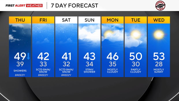
Cloudy skies and below normal temperatures will linger through the next several days into early next week. A gradual warming trend is expected by the middle of the week with daytime highs reaching the lower 50s next Tuesday and Wednesday although chilly nights and frosty mornings will likely continue with dry conditions.