It's going to be another dry day in the Pittsburgh area

It's going to be another dry day in the Pittsburgh area before rain chances return to the forecast tomorrow.
Any Alert Days Ahead? Potential for a couple of First Alert Weather Days early next week as we get into a rainy pattern, with wind storms also looking possible
Aware: Pittsburgh is less than 2 inches away from hitting our yearly average rain of 39.61". It appears we will surpass the yearly average next week with a wet pattern in place.
I think we have two more dry summer days before summer ends next Tuesday. Today will be one of them, with Friday being the other one. Besides that, we will see plenty of rain over the next week, with a rainy pattern setting up for early next week on the last days of summer.
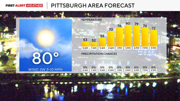
Today is looking dry, with plenty of sunshine around for the afternoon, similar to what we saw yesterday. Yesterday's high temperature hit just 71°, and today will likely see highs around 10 degrees warmer than that. I have Pittsburgh seeing a high of 80 degrees. Morning temperatures are the coolest we have seen in some time, with morning lows in the low 50s and some areas seeing 40s. I have noon temperatures in the mid to low 70s. There will be a wind change today, with morning winds coming in from the east and afternoon winds of 5 - 10 mph coming in from the south. I expect some pockets of fog to be around through at least 9 a.m. and potentially 10 a.m. in some valley areas.
While rain chances return on Wednesday, most of the day is looking dry, with the best chance for rain happening fairly late in the day and wrapping up early on Thursday morning. Wednesday highs will be in the mid-80s, with the 84° high that I am forecasting potentially being the hottest day of the week. The cool front that causes Wednesday's rain will likely stall out right on top of us with a west-to-east direction. This will allow weak lift to remain in place, with rain and storms firing off of the boundary through the day on Thursday. Keep the umbrella handy on Thursday, including for the Pitt game Thursday night at Acrisure Stadium.
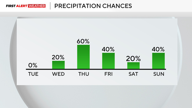
Looking to the weekend, Friday is looking dry. Rain chances return on Saturday. We will be right around the lip of a ridge of high pressure anchored over Georgia and Florida, with moisture moving in from the southwest. This set-up could produce plenty of rain and will not change for a couple of days. The wettest days of the next week and a half look to occur Saturday through Tuesday, with a couple of additional inches of rain certainly possible. While things can change, normally this type of set-up doesn't see big changes, so my confidence is in the moderate range for the rainy set-up at this point.
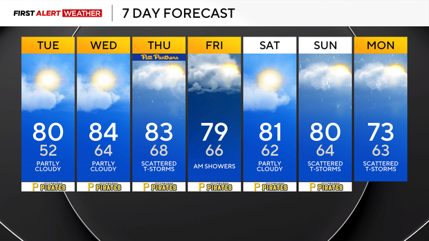
Saturday and Sunday highs will be near 80 degrees, but Monday and Tuesday highs are just expected to be in the low 70s.


