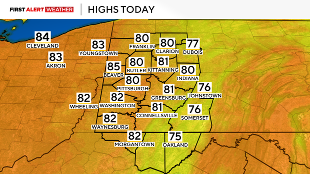
High temperatures in the Pittsburgh area will be near 80 degrees today

We have a chance to hit 80 degrees today in the Pittsburgh area.
Any alert days ahead? While there are two storm chances in place for this week, storms are expected to remain below First Alert criteria.
The average final 80° day of the year for Pittsburgh is October 4th, with the latest 80° day being on November 5th (2024). Last year's final 80-degree day of the year occurred on October 6th. Historically, we have had only 6 years where we saw 80-degree highs in November. We have had around 40 80° days that have occurred on or after October 13th. Records stretch all the way back to 1875.
I have Pittsburgh hitting 80° for the daily high. There will be some patchy fog around in the morning hours. That gives way to mostly sunny skies for the afternoon. Morning temperatures bottomed out in the 50s in most places, with noon temperatures expected to be in the mid-70s. I have afternoon winds coming in from the south at around 12 mph.
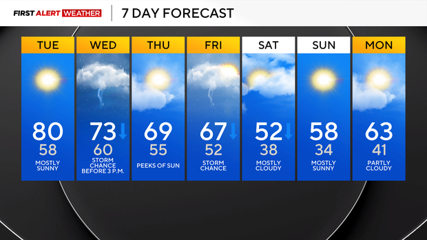
Our next rain and storm chance comes on Wednesday morning, with a west-to-east lined cold front sliding to the south. Isolated showers and some rain will be possible during the morning rush, especially for places along and north of I-80. I have rain and storms arriving in Pittsburgh around 10 a.m. The storm chances for Pittsburgh will be done by noon. Places south of I-70 can expect rain to continue into the early afternoon with the front slowing moving to the south. The biggest issue will be brief downpours and some gusty winds. Any lightning storms will also bring a risk of small hail, but that chance will be lower. A small sliver of our area south of I-70 is included in the severe weather risk (marginal) for Wednesday, but that chance is extremely low.
When it comes to your forecast, temperatures will be falling through the afternoon on Wednesday, with highs hit around 10 a.m. I have Wednesday highs in the mid to low 70s. Afternoon temperatures will be in the 60s on Wednesday. Thursday highs will be near 70, with Thursday morning lows in the mid-50s. Friday will see a brief warm front slide through around sunrise before a cold front moves through around noon. Friday highs will hit the mid to upper 60s in the morning with scattered rain and storms around. Temperatures will fall through the afternoon and evening hours. This will set up some chilly weekend weather with temperatures in the afternoon on Saturday just around 50 degrees and Sunday highs in the upper 50s. The real story for both days will be the cold mornings with morning lows in the upper 30s on Saturday and mid to low 30s on Sunday.
We may get our first snow reports of the season coming from the Laurel Highlands. Any snow is not expected to be substantial.


