Wednesday will be coldest morning of the week in Pittsburgh, but warmer temperatures loom
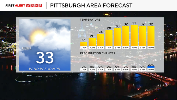
When it comes to air temperature (and not wind chills), today will be the coldest morning of the week, with morning lows dipping down to the mid-teens. Pittsburgh will likely see a morning low of around 15°.
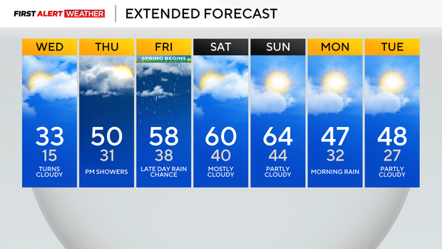
Wind speeds will be calm to light and won't be strong enough for a significant difference. Highs today will be in the mid to low 30s. Model data over the past 12 hours has really dropped today's high, and a big reason for that is the snow that's on the ground. I have highs today, hitting 33 degrees in Pittsburgh, with that temperature not being reached until around 6 p.m.
Warmer air begins to roll in overnight.
Thursday morning temperatures will be in the 30s, near today's high temperature, actually, due to the warmer air rolling in on the backside of the shortwave trough. Temperatures will begin to warm for the rest of the week. I have highs hitting 50 degrees on Thursday. Friday highs should be near 60 degrees. Saturday and Sunday both should see highs in the 60s.
Rain chances over the next week remain fairly low, and no days are screaming 'severe weather chance.' I have a light snow chance tonight as the short wave moves out. I have a brief afternoon rain chance on Thursday and Friday. Thursday's chance is another fast-moving mid-level low. It's a front and warmer air moving in that gives us the rain chance on Friday into Saturday morning.
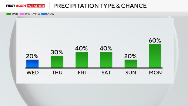
Our best chance for rain for the week may very well be late Sunday into Monday with a cold front that passes by. Right now the front's timing is the main thing keeping severe weather chances in check.