Cold front in Pittsburgh brings late-day rain on Friday, cooler temperatures on Saturday
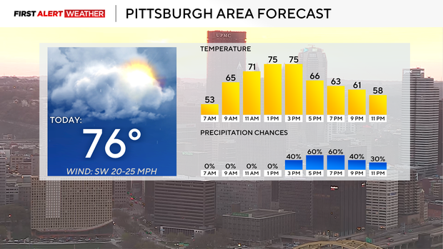
Talk about a split personality; the first part of today will be fantastic with plenty of sunshine and temperatures quickly soaring to the mid-70s.
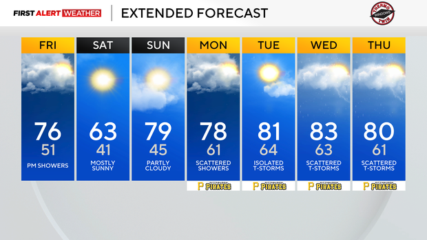
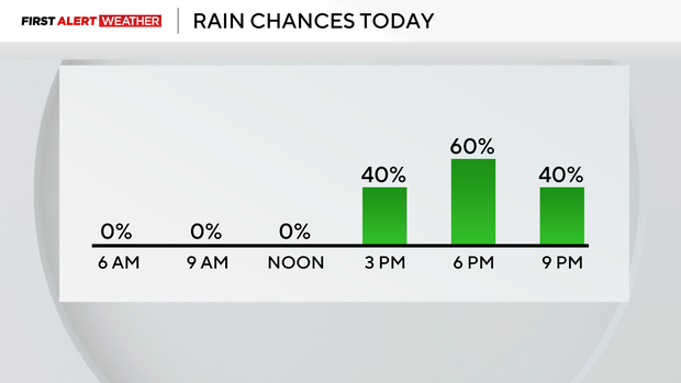
Clouds will roll in as we head into the afternoon, with rain chances arriving after 5 p.m. Once the rain arrives, temperatures will quickly dip to the low 60s for the rest of the evening. Morning temperatures on Saturday will fall to the 50s.
Highs behind the cold front on Saturday will hit the mid to low 60s.
Besides the afternoon to evening rain today, the weather will be pleasant for the remainder of the weekend. Saturday won't be as warm, but temperatures will still be well over the average high of 60 degrees for this time of the year.
Skies will also be mostly sunny on Saturday. It will be perfect for maybe getting out for an early morning run or outdoor yardwork. Sunday will see temperatures warm back up to near 80 degrees. The warm front that brings a return of the near record high temperatures rolls through on Sunday morning, and I have an isolated shower chance as it comes through.
At this point, places to the northwest will have the 'best' chance to see a passing shower. It's still low.
Looking ahead, the jet stream will be near our area all next week, and we may see storms fueled by the jet's energy developing on a day or two next week.
Nothing right now is sticking out as the day to watch out for when it comes to severe weather. Temperatures all of next week are also expected to be on the warm side with highs up near 80 degrees.
That will put us a good 15 to 25 degrees above normal.