Cloudy but cool weather sticks around the Pittsburgh region before a weekend warm up
This morning, the skies are mostly cloudy with some isolated areas of fog, but a light breeze is helping prevent more fog from developing. Winds are out of the northeast, and that is helping to bring in some slightly drier air today.
WEATHER LINKS:
Current Conditions | School Closings & Delays | Submit Your Weather Photos
The northeast breeze is part of the wind flow behind a cold front dissolving across our area, plus the large-scale circulation pattern around the periphery of Hurricane Erin as it moves up the East Coast.

With a weak boundary in place across the area, there is a low chance of a stray shower today, mainly between the I-79 corridor and the westward-facing slopes of the Laurel Highlands. With skies that are expected to remain mostly cloudy for a good portion of the day, highs will likely stay in the upper 70s for most, with a few locations getting closer to 80 degrees.

Overnight, skies will clear out, and with continued northeasterly flow, dry air and cooler temperatures will be the final result. Lows Friday morning will be in the mid-50s to low 60s. High temperatures on Friday will reach the mid-80s, then the upper 80s are expected on Saturday as southwest winds increase ahead of another stronger trough of low pressure and approaching cold front.
This will bring a chance of some isolated evening storms Saturday into the predawn hours of Sunday. As a second stronger trough embedded within the flow moves in Sunday night into Monday, there will be additional scattered showers followed by a strong cold front that will give us a preview of fall for early next week.

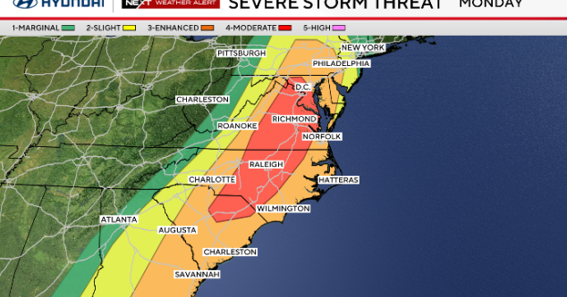
At the moment, severe weather is not an overarching threat on Sunday, but with stronger wind shear in place compared to previous events, more organized and long-lived storms cannot be ruled out. Below-average temperatures are expected from early into the middle of next week!

Stay up to date with the KDKA Mobile App – which you can download here!