More clouds in Philadelphia Monday, when we'll see the sun return
Cloudy, foggy conditions will continue in the Philadelphia region Monday. Meteorologist Andrew Kozak has the forecast.
Watch CBS News
Cloudy, foggy conditions will continue in the Philadelphia region Monday. Meteorologist Andrew Kozak has the forecast.

The Philadelphia region can expect more clouds and some showers Monday and Tuesday, but things will clear up later in the week. Meteorologist Andrew Kozak has the forecast.
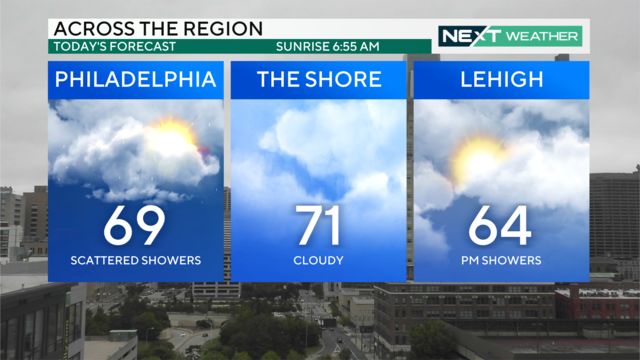
Sunday will be overcast with spotty showers throughout the morning and afternoon. A few steadier showers are possible overnight into Monday.

The outer bands of Hurricane Helene brought cloudy skies and spotty showers to the Delaware Valley, and those conditions will continue as we head into the work week. The Philadelphia area could see some peeks of sun Monday, but the next mostly sunny day doesn't come until Thursday.

Turning to the forecast, a gray and wet night across the region. Things dried out a bit in some places, many made their way out to Dilworth Park. It sounds like we do have some sunshine to look forward to. Meteorologist Andrew Kozak reports another look at your NEXT Weather forecast.

Taking a live look over downtown Bethlehem, it has been a rainy and grey start to the weekend. Meteorologist Andrew Kozak reports our NEXT Weather forecast.

Saturday is cloudy with some rain, but we're not complaining since we need this precipitation.

Mostly cloudy skies, off-and-on showers and humid conditions in Philadelphia on Saturday as the moisture from Helene heads this way. Bill Kelly reports.

The next several days will bring similar weather conditions, day in and day out around the Philadelphia area. That means mostly cloudy skies, off-and-on showers and humid conditions as the moisture from Helene heads this way. A NEXT Weather Alert is in effect overnight due to moisture from Helene.

The next several days will bring similar weather conditions to the Philadelphia area. That means mostly cloudy skies, off-and-on showers, and humid conditions as the moisture from Helene heads this way.

Dense fog is reducing visibility on the roads in New Jersey and parts of Pennsylvania. We've issued a NEXT Weather Alert for this fog, Meteorologist Kate Bilo explains. Meantime, we're tracking the path of Helene after it has been downgraded to a tropical storm - and could bring showers to the Philadelphia area late Friday into Saturday.

Bill Kelly has your NEXT Weather forecast as Hurricane Helene makes landfall in Florida.

Bill Kelly has the latest NEXT Weather forecast for the Philadelphia region as we track the latest developments of Hurricane Helene and more.

Hurricane Helene is forecasted to make landfall in the Big Bend region of Florida Thursday evening, before moving north over Georgia and South Carolina and then hooking west into Tennessee. Meteorologist Kate Bilo has the latest on the storm's track and your Philadelphia-area weather forecast for Thursday, which includes chances of showers.

Bill Kelly says the Philadelphia region will experience some showers in the morning on Thursday. After that, it will be cloudy and warmer.

We've seen off and on rain this Wednesday. If you're heading out, might want to have the rain gear with you. Let's see what's next from the NEXT WeatherSphere with Chief Meteorologist Bill Kelly.

We have an elevated chance of rain for Saturday in the Philadelphia area due to Hurricane Helene, which will head north after making landfall in Florida. NEXT Weather Meteorologist Grant Gilmore has the forecast.

While most models project Helene will not move toward the Philadelphia region, some stray bands of tropical downpours may impact us on Friday and Saturday, NEXT Weather Meteorologist Kate Bilo explains.

Wednesday in the Philadelphia region will be cloudy with scattered showers. Chief Meteorologist Bill Kelly has the forecast and the latest on the track of Tropical Storm Helene.

Bill Kelly has your NEXT Weather forecast for Tuesday night ahead of scattered showers on Wednesday in the Philadelphia region.

Tropical Storm Helene has now formed and one possible track could push some moisture into the Philadelphia area later this week. NEXT Weather Meteorologist Grant Gilmore breaks it down.

After parts of New Jersey including Atlantic City experienced coastal flooding on Monday, a coastal flood advisory is in effect on Tuesday, NEXT Weather Meteorologist Kate Bilo reports. All around the Philadelphia region we could see chances of rain Tuesday that pick up on Wednesday.

Showers are possible in the Philadelphia region Tuesday. Chief Meteorologist Bill Kelly has the forecast.

Temperatures Monday will be about five degrees cooler than normal with highs in the low 70s. Mostly cloudy skies tonight will keep temperatures from dropping too much as they return to the upper 60s Tuesday morning.

Monday will be mostly cloudy in the Philadelphia area and Delaware Valley, with a slight chance for a few sprinkles and showers. The best chance for rain is closer to the Lehigh Valley later in the day. The region could see a little more sun tomorrow, and right now the best chance for more widespread rain looks to be Wednesday.