NEXT Weather: Sunny, temperatures in 50s before Sunday-Monday storm
Cherish these sunny days before rain arrives Sunday night into Monday in the the Philadelphia region, Tammie Souza reports.
Watch CBS News
Cherish these sunny days before rain arrives Sunday night into Monday in the the Philadelphia region, Tammie Souza reports.

The Philadelphia region is in for another chilly night with temperatures dropping into the upper 20s and low 30s late Thursday. We bounce back Friday with high temperatures in the low to middle 50s. We’ll hang onto the 50s through the weekend before our next storm system arrives Sunday into Monday.

Grant Gilmore has the latest weather forecast for the Philadelphia area.

Thursday is cold but sunny, but a warm-up is on the way Friday and Saturday, Tammie Souza reports.
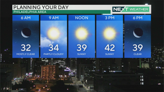
Thursday will be the coolest day of the week with highs in the low 40s, but warmer temperatures in the 50s return Friday.

High temps will make it into the low 40s Thursday before the warm weather rebounds heading into the weekend. But more chances of rain return Sunday into Monday. Kate Bilo has your forecast.

The region can expect temperatures to drop into the mid- to upper-20s Thursday, and it might feel colder. Temperatures will warm up into the 50s on Friday and Saturday, with wind and rain expected Sunday.

Grant Gilmore has the latest weather forecast for the Philadelphia region.

It will be seasonably chilly on Wednesday and even colder on Thursday. Andrew Kozak has your forecast.
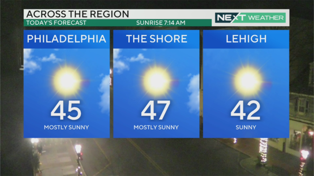
Another sunny day Wednesday before a front passes ushers in colder air Thursday, when temps will struggle to make it to 40.

Another sunny day Wednesday before a front passes through later tonight and ushers in a northerly flow for Thursday, meaning temperatures will drop even further. Many spots could barely make it to 40! Kate Bilo has your morning forecast.

Bill Kelly says Wednesday will be sunny and chilly in the Philadelphia region with a high of 45.

Bill Kelly has the latest weather forecast for the Philadelphia region.

The weather story the next few days will be the relatively cold air, especially when accounting for wind chill, however we will have a dry trend through at least Saturday.
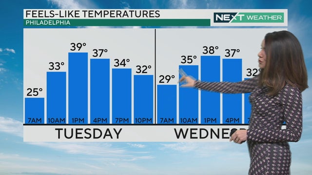
Tuesday and Wednesday will be seasonable days with temperatures in the mid-to-upper upper 40s, though a breeze will make it feel a little cooler. The coldest day of the week comes on Thursday, with highs only in the 30s.

After a rainy weekend, more sunshine is on the way this week. Highs Tuesday and Wednesday will be in the 40s, but breezy conditions and wind chills will make it feel a bit cooler. Kate Bilo has your forecast.

Bill Kelly says Tuesday in the Philadelphia region will be clear and chilly.

Bill Kelly has the latest weather forecast for the Philadelphia region.

A storm that began Sunday and led to three record daily rainfall maximums will wrap up Monday morning, but not before a band of light snow pushes through the area.

Rain continued through the overnight hours Sunday into Monday in the Philadelphia region and changed to snow in some places. Precipitation will end by mid-morning Monday.

A wintry mix will likely impact your Monday morning commute as snow and rain falls across the region. Once the storm wraps up around 8 or 9 a.m., we'll be dealing with cold temps and blustery winds. Kate Bilo has your forecast. https://www.cbsnews.com/philadelphia/news/philadelphia-weather-today-rain-wind-dec-10/

Bill Kelly has everything you need to know for the current storm system hitting the Philadelphia region.

Andrew Kozak is tracking the latest storms moving across the Delaware Valley.

A Flood Watch is in effect from 1 p.m. Sunday until 4 p.m. Monday as a strong storm moves into the area. Expect heavy rain, gusty winds up to 30-50 mph and a few rumbles of thunder. Rain continues overnight before wrapping up later Monday morning.

Meteorologist Grant Gilmore is tracking rain and wind coming to the Philadelphia area Sunday night.