Fog and clouds with patchy drizzle this Saturday in Philadelphia region. Here's the forecast.

The low clouds, fog and drizzle that started our Saturday will lift, but skies will remain mostly cloudy through the day.
Most of Saturday afternoon will be dry, but a few areas of drizzle will be possible closer to the Jersey Shore.
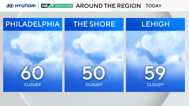
High temperatures will peak near 60 degrees. The Shore, however, will remain 10-15 degrees cooler all weekend as winds will be mainly onshore.
A warm front to our south will lift through the region overnight and bring a surge of warmth and moisture with it. Temperatures will remain in the low 50s tonight with cloudy conditions and areas of light drizzle.
The winds will also begin to increase as the warm front pushes north, gusting to around 25 mph Sunday morning.
Timing out storms for Sunday
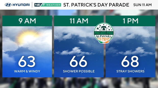
Temperatures will gradually warm through the 60s Sunday morning despite overcast skies and increasingly windy conditions. Highs Sunday afternoon will be near 70 degrees.
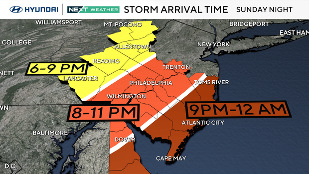
The first half of Sunday will only have a few stray showers before a strong line of storms approaches out ahead of a cold front into Sunday evening.
This line of storms will bring areas of heavy rain and embedded strong and potentially damaging wind gusts. This line of storms will arrive in the Reading and Allentown area between 6 - 9 p.m. and then track east into the Philadelphia area by 8-11 p.m.
The leading edge of the storms will move across South Jersey toward the shore into the first half of the overnight.
What is the severe weather risk in Pennsylvania, New Jersey and Delaware?
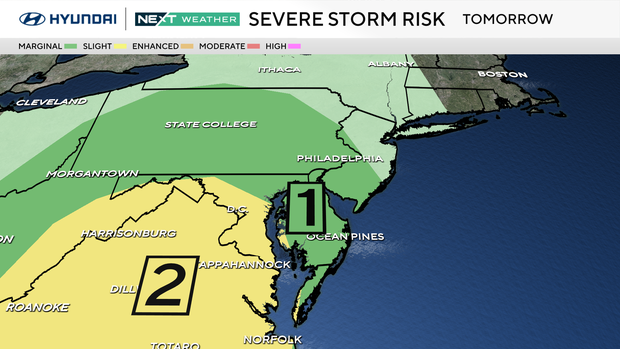
The Storm Prediction Center has included the Philadelphia region in a Marginal risk of severe weather, Level 1 of 5.
Threats include damaging winds, heavy rain, and the possibility of an isolated tornado.
Impacts could include downed trees, power outages, localized flooding, and travel delays by air, road, and rail.
The NEXT Weather Team will have frequent updates online, on-air and on our CBS News Philadelphia stream to help you to plan and stay protected.
St. Patrick's Day parade weather in Philadelphia on Sunday
Monday, St. Patrick's Day will start with some green (rain) on the radar before slowly clearing out through midday. The rain and clouds will gradually clear for the afternoon with temperatures near 60 degrees.
The warmth will return through the middle of next week with highs in the mid-upper 60s Tuesday and then around 70 degrees Wednesday.
The next chance of rain will arrive with the first day of spring on Thursday as a cold front ushers in another drop in temperatures for next Friday. Temperatures will go from the upper 60s Thursday afternoon to only around 50 degrees Friday afternoon.
7-day forecast
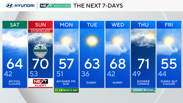
Saturday: AM fog, clouds. High of 64, low of 42.
Sunday: NEXT Weather Alert for late storms. High of 70, low of 53.
Monday: AM shower, PM sun. High of 57, low of 51.
Tuesday: Sunny. High of 63, low 36.
Wednesday: Sunny. High of 68, low of 42.
Thursday: Shower chance. High of 71, low of 49.
Friday: Sunny, but cooler. High of 55, low of 44.
Get the latest weather info on the CBS News Philadelphia app.