Philadelphia hits 100 degrees for the first time since July 2012 during heat wave

Today's weather in the Philadelphia area is the hottest of this heat wave so far, with a high of 100 degrees that will feel even warmer thanks to the humidity.
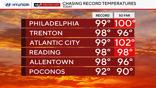
We've been reporting for days that temperatures could hit record-breaking highs, and on Tuesday, at least three records were broken or tied.
The highest temperatures on record for Philadelphia and the Atlantic City Airport were both broken, while the record in Reading, Pennsylvania, was tied. This is the first time Philadelphia has hit 100 degrees since July 18, 2012.
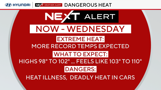
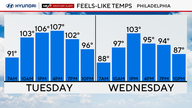
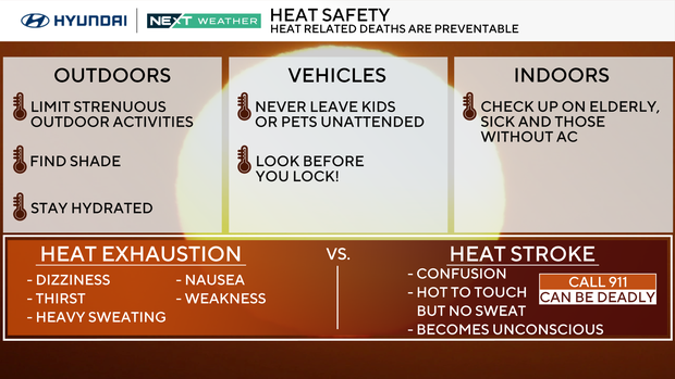
At the height of the afternoon, it will feel like 105-110. Avoid the outdoors if possible, or take regular breaks in air conditioning, and remember to stay hydrated.
Air quality won't be great either, as hot, still air can cause ozone to become stuck in our air on the surface. On Tuesday, Camden County issued a Code Orange air quality alert for ozone, noting that levels of the gas would reach levels unhealthy for sensitive groups. Those groups — the elderly, the very young and people with health conditions — should limit time outdoors.
Additional air quality alerts may be issued before the end of the week.
Get ready to repeat this process Wednesday; consequently, a NEXT Weather Alert is in place through Wednesday.
Wednesday, the heat dome begins to degrade a bit, allowing a better chance for showers and storms, some of which may turn briefly strong or severe — intense downpours will also be possible.
Once we get past this heat, the unstable air returns, and the storm door will open through the weekend.
Heat warnings, advisories, air quality concerns
Multiple weather alerts and advisories are in effect because of the heat wave.
- Extreme heat warning: An extreme heat warning is in effect now until Wednesday evening for all of Pennsylvania, New Jersey and Delaware counties along the Interstate 95 corridor.
- Heat advisory: A heat advisory is also in effect now until Wednesday evening for South Jersey away from I-95, the Jersey Shore, southern Delaware and the Poconos.
- Air quality alert: There is also a code orange air quality alert in effect in the Philadelphia region on Tuesday. The elderly, small children and those with respiratory problems should stay indoors as much as possible. Concerned about the air quality in your neighborhood? Check out AirNow.gov to see how conditions are in your area.
How to stay cool in Philadelphia
The City of Philadelphia's Department of Public Health has declared a heat health emergency, effective now through Wednesday night. The emergency could be extended if the forecast changes and this heat wave continues.
Due to the heat health emergency, the city has activated its emergency heat programs, including Philadelphia's Corporation for Aging's Heatline, cooling centers, home visits by special field teams and enhanced daytime outreach for those experiencing homelessness.
A full list of cooling centers, spraygrounds and pools in Philadelphia is available online.
Tips for surviving the heat wave
Make sure to hydrate with nonalcoholic and non-sugary drinks. Spend time in the air conditioning, and if overheated, try a cool shower.
Never leave people or pets in a car; the heat builds quickly, and it can be deadly in minutes. Check on family and friends.
Finally, keep pets indoors or in a shaded area with clean, cool water. Don't walk dogs on the hot pavement; their paws can burn.
Heat wave facts
- Last year's first heat wave lasted from June 18 to 23, and the most recent heat wave of 2024 occurred at the end of July. Both topped out at 98 degrees.
- And the longest heatwave on record? A whopping 12 days back in 1901, including two scorchers over 100 degrees.
Here's your 7-day forecast:
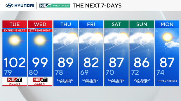
Tuesday: NEXT Weather Alert for extreme heat. High 102, Low 79.
Wednesday: NEXT Weather Alert for extreme heat. High 99, Low 80.
Thursday: Scattered storms. High 89, Low 79.
Friday: Scattered storms. High 82, Low 69.
Saturday: Scattered storms. High 87, Low 70.
Sunday: Scattered storms. High 86, Low 72.
Monday: Stray storm. High 87, Low 74.