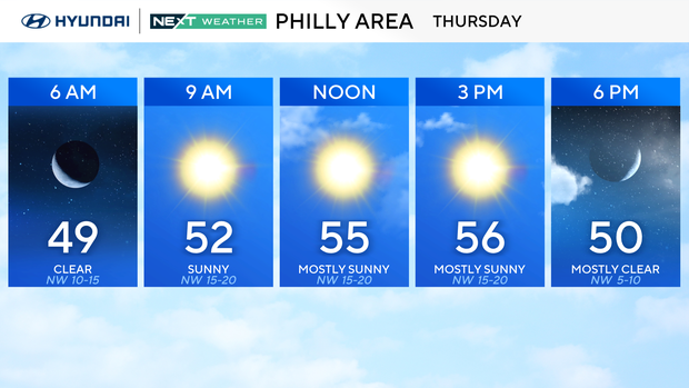
Breezy and cooler weather Thursday in Philadelphia area, tracking colder temps on the way. Here's the forecast.
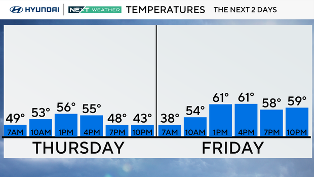
Winds will remain gusty on Thursday behind the front that crossed the Philadelphia area Wednesday evening, bringing much cooler temperatures for the day.
Wind gusts will be weaker than Wednesday, when a strong cold front blasted through. Thursday afternoon and evening, winds gradually die down, and we'll have a cold night, likely the coldest yet in Philadelphia, where we haven't dropped below 40 degrees yet. Thursday night, we might.
Frost advisories are in effect across Philadelphia and Delaware counties along with South Jersey and Delaware.
High temperatures will go from the upper 60s and low 70s Wednesday to the 40s and 50s Thursday before warming back into the 60s Friday.
A stronger system approaches Friday night with rain and gusty winds and could spark a shower. That will mark the start of a more unsettled weekend pattern with the greatest chance of rain coming on Sunday.
That rain will be from an even stronger and colder front that will bring significant changes to the area.
Next week: COLD! Highs Monday and Tuesday will only stay in the mid-upper 40s with widespread freezing temps likely by Tuesday morning, and when you add the breeze to the mix, wind chill temps by Tuesday morning will likely dip into the 20s and possibly some teens in spots.
If you haven't broken out the cold weather gear yet, this weekend will be the time to do it!
Here's your 7-day forecast:
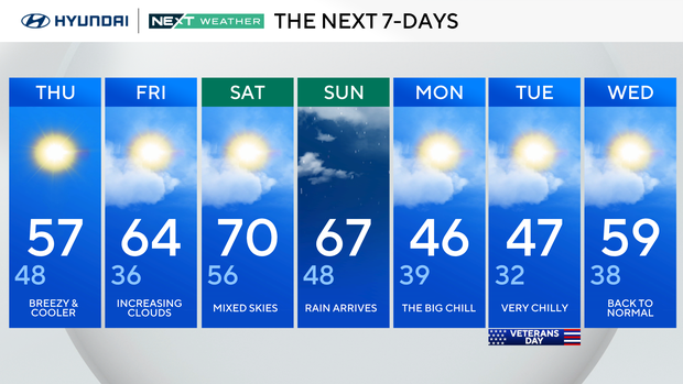
Thursday: Breezy and cooler. High 57, Low 48.
Friday: Increasing clouds. High 64, Low 36.
Saturday: Mixed skies. High 70, Low 56.
Sunday: Rain arrives. High 67, Low 48.
Monday: The big chill. High 46, Low 39.
Tuesday: Very chilly. High 47, Low 32.
Wednesday: Back to normal. High 59, Low 38.