Dangerous deep freeze in the Philadelphia area could make roads, sidewalks slick. Here's the weather forecast.

Dangerous cold arrives Monday night in the Philadelphia area.
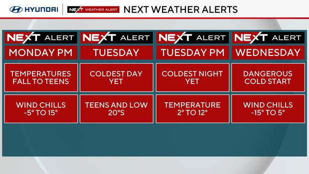
We've issued NEXT Weather Alerts for Monday, Tuesday and Wednesday for this freezing cold weather and potentially poor road conditions after the snowy weekend.
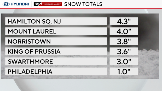
Philadelphia-area snow totals
Philadelphia got 1 inch of snow, but parts of South Jersey got 4 inches or more. Here are the latest totals around the region:
Here's the NEXT big change
Monday night brings the most dangerous and coldest air of the season so far. Expect cold alerts and Code Blue alerts to be issued, with local governments opening warming centers.
By Monday evening, temperatures are in the 20s and upper teens, with wind chills in the single digits and low teens.
Overnight lows Monday will dip to the teens and single digits under clear skies.
Cold alerts for Tuesday, Wednesday
Tuesday and Wednesday could be so cold that schools close or open late.
Tuesday morning wind chills will be between -15 to 5 degrees.
Tuesday will be the coldest day of the season so far. Highs will only be in the low 20s, while wind chills will be in the teens and single digits.
Tuesday night we could drop as low as 9 degrees in the city, and even colder away from the city. If we hit a low of 9, it will be the first time that's happened in Philly since Dec. 23, 2022.
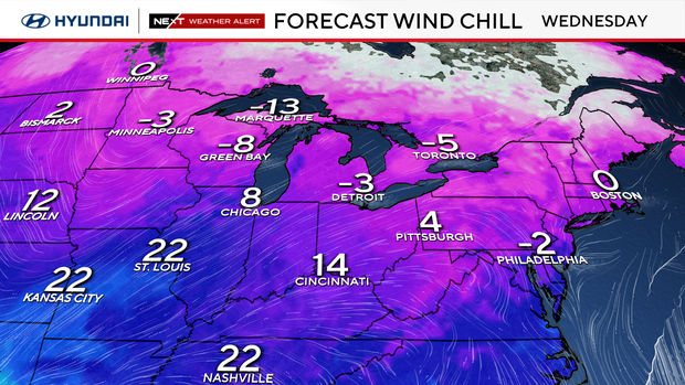
Wednesday morning will be the worst of the cold, with wind chills of -15 degrees to 5 degrees. If you look at the map above, we could be colder on Wednesday than Winnipeg, Canada!
Our NEXT Weather Alert will expire at 10 a.m. Wednesday.
After that, we are monitoring a possible snow event for late next weekend — the NEXT Weather team will keep you updated as that forecast develops.
Here's your 7-day forecast:
Monday: NEXT Weather Alert for a frigid morning and night. High 34, Low 20
Tuesday: NEXT Weather Alert for the coldest air of the season yet. High 23, Low 15
Wednesday: NEXT Weather Alert for a morning wind chill ranging from the single digits to below zero. High 36, Low 13
Thursday: Partly cloudy. High 42, Low 32
Friday: Partly cloudy. High 34, Low 28
Saturday: Chance of snow. High 30, Low 22
Sunday: Chance of snow. High 23, Low 13


