More triple-digit heat for North Texas as rain chances return late weekend


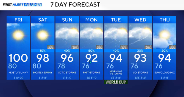
Another triple-digit day:Wednesday reached 101° at DFW, and we're likely to reach 100° again Thursday and Friday.
While it's hot, we're still well below record levels for July. Heat peaks before relief: Thursday through Saturday will be the hottest stretch, with the hottest temperatures west of I-35.
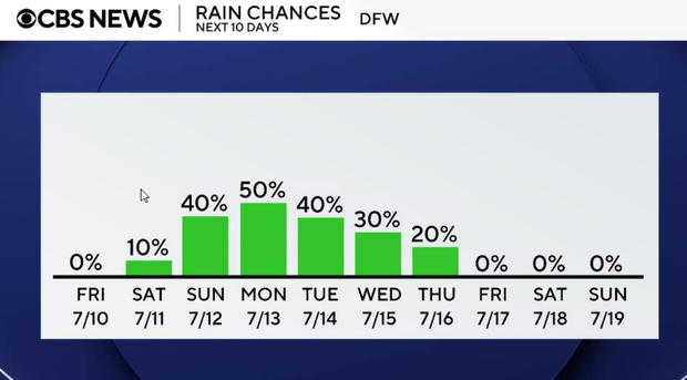
Pattern change this weekend: a weak front arrives late Saturday, bringing our best rain chances in several days. Scattered thunderstorms become more widespread Sunday into Monday, helping temperatures return closer to normal.
Clear and hot Thursday and Friday
A few northeastern counties may briefly see heat index values around 105°, but most locations remain just below heat advisory criteria. It will be clear and very hot with temperatures near 100° across most of North Texas. Overnight lows Thursday remain in the middle to upper 70s with a light to occasionally breezy south wind.
Friday is another hot summer day with abundant sunshine. Highs once again reach 99° to 101° with heat index values near 104°.
Sunny and hot this weekend before storm chances return
Highs will be in the upper 90s on Saturday. Clouds begin increasing late in the day as a weak front approaches. A few storms may begin developing Saturday evening, especially across northern and southeastern portions of the area.
Storm chances begin increasing Saturday night as thunderstorms developing to our north move toward North Texas overnight. Not everyone will receive rain, but this marks the beginning of a wetter pattern.
Sunday, scattered showers and thunderstorms become more numerous as a weak front settles into North Texas. Rain chances range from 40%, with locally heavy rainfall possible. Severe weather appears unlikely, but slow-moving storms could produce brief flooding. Highs cool back into the mid 90s.
Monday will be another active day with scattered showers and thunderstorms, especially along and south of I-20. Rain chances remain 50%, and locally heavy rainfall will again be possible. Highs stay in the mid-90s.
Tuesday, morning showers and storms are still possible. Rain chances gradually decrease during the afternoon but remain in the forecast, mainly south of I-20. Highs stay near seasonal normals in the mid 90s.
Only isolated storm chances remain on Wednesday as the wetter pattern shifts south. Temperatures begin warming again into the upper 90s.