Rain moves out for most of Philadelphia region, tracking nor'easter. Here's the weather forecast.
We finally have a pretty nice day inland! It's mostly cloudy and 55 in Philadelphia this morning, but the clouds should continue breaking for increasing sunshine as we head toward midday and afternoon. Highs reach the upper 60s.
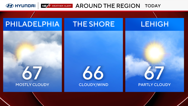
The northeast breeze is still noticeable, but humidity is very low with dewpoints in the 40s, so it will feel crisp and comfortable. Sunglasses yes, umbrella no around Philadelphia and the suburbs. Outdoor plans are in good shape through the rest of the day, although you may want a light jacket if you'll be outside for any length of time.
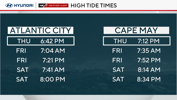
The Shore remains a completely different story. This is not a beach or ocean day. Strong northeast winds continue to pile water toward the coast, with rough surf, significant beach erosion and additional rounds of coastal flooding expected through Saturday.
NEXT big weather changes
We finally have a much clearer picture of the nor'easter, and it's good news for Philadelphia.
The storm is strengthening offshore, but the latest guidance has come into much better agreement on keeping the core of the system far enough east that at least significant rain should stay away from Philadelphia. Instead, the storm heads toward southern New England, where the strongest wind and heaviest rain are increasingly likely this weekend, but the storm could stall and possibly loop back toward the coast on Sunday.
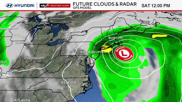
The shore will bear the brunt of the impacts across our region. The pressure difference between the offshore storm and strong high pressure to our north keeps a persistent northeast wind going, and the ocean has already had several days to build. Coastal flooding, dangerous surf and beach erosion remain concerns through several more high-tide cycles.
Clouds will increase tomorrow and a few showers may rotate inland from the shore by evening, though the majority of our Friday looks dry in the city.
The weekend is still the trickier part of the forecast. Saturday turns cooler and cloudier with highs only in the mid 60s. While a few rounds of showers are possible, it doesn't look like a washout around Philadelphia. Sunday is the wildcard. There is still some potential for the nor'easter to loop or retrograde back toward the coast as it slows down, which could bring some showers back into our area. For now, that looks more like a shower chance than a major storm for Philadelphia.
The pattern improves considerably next week. Monday trends drier, then sunshine returns Tuesday and Wednesday with temperatures rebounding well into the 70s.
So the bottom line: Next Weather Alert continues at the Shore through Sunday. Coastal flooding, strong winds, dangerous surf and beach erosion remain the primary concerns, while inland impacts from the nor'easter are considerably less significant - though a few rounds of showers could mean impacts on any weekend outdoor plans.
Here's your 7-day forecast:
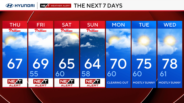
Thursday: NEXT Weather Alert. High 67
Friday: NEXT Weather Alert. High 69, Low 55
Saturday: NEXT Weather Alert. High 65, Low 60
Sunday: NEXT Weather Alert. High 64, Low 58
Monday: Clearing out. High 70, Low 60
Tuesday: Mostly sunny. High 75, Low 60
Wednesday: Mostly sunny. High 78, Low 61
Get the latest weather info on the CBS News Philadelphia app.


