Will nor'easter hit Philadelphia region? Here's what to know about timing and more


A nor'easter developing off the East Coast will bring several days of rough conditions to the Jersey Shore and Delaware beaches this week.
The biggest question is what happens with that storm later in the week. The answer could make a major difference in how much rain and wind we see across the rest of the Philadelphia region.
What to know about nor'easter set to hit New Jersey, Delaware
Low pressure is developing off the Carolina coast and is expected to strengthen as it moves northeast over the western Atlantic. At the same time, strong high pressure will remain to our north over eastern Canada.
Think of our region as being squeezed between those two weather systems. That will create a tight pressure difference and a persistent northeast wind, especially along the coast.
Conditions began deteriorating at the shore Tuesday and became rougher Wednesday.
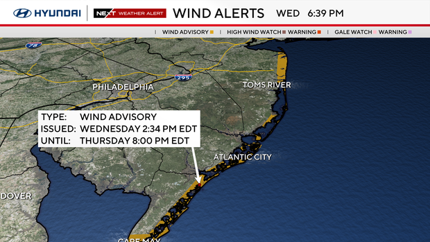
A wind advisory is in effect for the immediate New Jersey and Delaware coasts through 8 p.m. Thursday, with northeast winds of 25 to 35 mph that could gust as high as 45 mph. Those winds could bring down tree limbs and power lines.
A high rip current risk remains in effect through Friday, and a high surf advisory is in effect through Friday evening. Breaking waves of 6 to 12 feet are expected. Significant beach erosion is likely as waves repeatedly pound the shoreline through the end of the week and likely into the weekend.
A big problem: coastal flooding
The prolonged northeast wind will push ocean water toward the shore and into the back bays and tidal waterways. Because that wind will continue for several days, water may have trouble fully draining between high-tide cycles.
The flooding threat increases through Friday and potentially into this weekend, depending on where the heart of the storm actually ends up.
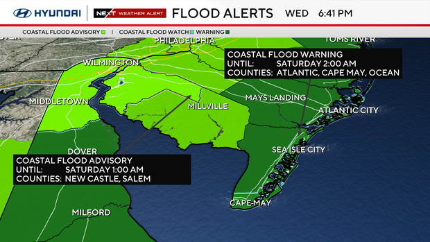
A coastal flood warning is in effect through 2 a.m. Saturday for the Jersey Shore and Delaware beaches. For perspective, Atlantic City is forecast to reach moderate flood stage through Saturday morning's high tide, with the possibility of reaching major stage. Similar levels are forecast around Barnegat Bay.
And another factor is working against us.
Saturday brings a full moon, which naturally produces higher astronomical tides. Combine those higher tides with several days of northeast winds and rough seas, and additional rounds of coastal flooding could continue into Friday or even the weekend. While major coastal flooding is not currently forecast, it cannot completely be ruled out if the setup becomes more favorable.
In addition to coastal and tidal flooding, coastal erosion will also be a concern due to the long duration of rough surf battering the beaches.
So where does the storm go?
This is where forecast confidence drops considerably.
Computer guidance has essentially split into two main camps for Friday and the weekend, and the difference between them is important.
Scenario 1: The storm stays offshore and north (GFS model)
In this scenario, the coastal low continues moving northeast and remains comfortably offshore.
That would be the better outcome for most of the Philadelphia region.
Rain would likely remain concentrated near the coast, with little or perhaps no rain farther inland. Winds would also begin easing sooner as the storm pulls away.
The Jersey Shore would not return to normal immediately. Several days of northeast winds will already have built up the ocean and pushed water toward the coast, so high surf, beach erosion and coastal flooding could linger even as the storm moves away.
For Philadelphia and areas farther north and west, however, this scenario would mean relatively limited impacts from the storm itself.
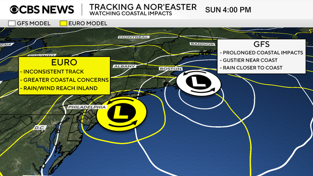
Scenario 2: The storm turns back toward the coast (Euro model)
The second scenario would bring considerably greater impacts.
Instead of continuing out to sea, the storm could turn northwest toward the Mid-Atlantic coast late Thursday into Friday.
If that happens, rain would spread much farther inland, potentially reaching Philadelphia and a larger portion of Pennsylvania and New Jersey. Winds would remain stronger for longer, and the persistent onshore flow could worsen coastal flooding and beach erosion.
Exactly where the storm tracks would determine where the heaviest rain and strongest winds occur. A track close to the Jersey Shore could bring a period of significant rain and wind to the area.
There's also a middle-ground possibility in which the storm makes somewhat of a turn toward the coast but ultimately remains offshore. That could still bring some rain and wind inland, but the greatest impacts would remain closer to the shore.
So which scenario will happen?
Your NEXT Weather team continues to monitor the latest but is leaning toward scenario 2 based on a variety of factors, including the inconsistencies from model run to model run. One individual model run is not a forecast.
The important part right now is separating what we know from what we're still trying to determine.
High confidence: Strong northeast winds, dangerous rip currents, 6- to 12-foot breaking waves, beach erosion and multiple rounds of coastal flooding will affect the Jersey Shore and Delaware beaches this week.
Lower confidence: How close the coastal storm gets to us late Thursday through Saturday, and therefore how much rain and wind reach Philadelphia and areas farther inland.
For now, there's no reason to assume the highest-impact scenario will happen. There's also enough support for a closer track that we cannot dismiss it.
The next couple of days should bring much better clarity as the storm develops and we see whether forecast guidance begins settling on one solution.
Either way, if you're headed to the Jersey Shore or Delaware beaches this week, this is already a significant coastal weather event. Stay out of the ocean, keep an eye on high-tide cycles if you're in a flood-prone community and expect conditions along the coast to remain rough for several days.


