Storms bring damaging winds, possible flooding to Philadelphia region Thursday. Here's the weather forecast.
Thursday is a NEXT Weather Alert day with a round of showers and thunderstorms becoming more widespread from midday through the afternoon and evening.
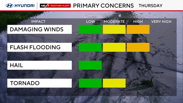
It will be very humid, and some storms could produce damaging winds, hail and torrential rain. An isolated tornado is also possible.
A tornado warning in Salem County, New Jersey, has been canceled.
A severe thunderstorm watch is in effect until 10 p.m. in Kent and New Castle counties in Delaware; Atlantic, Burlington, Camden, Cape May, Cumberland, Gloucester, Hunterdon, Mercer, Middlesex, Monmouth, Morris, Ocean, Salem, Somerset, Sussex and Warren counties in New Jersey; and Bucks, Chester, Delaware, Montgomery and Philadelphia counties in Pennsylvania.
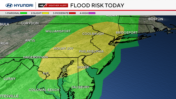
A flood watch is in effect across most of the Philadelphia region. Most spots won't see flooding, but repeated heavy downpours could produce localized flash flooding, especially along the I-95 corridor and north and west.
Flash flood warnings are also in effect Thursday afternoon in Camden, Gloucester and Salem counties in New Jersey; New Castle County, Delaware; and Delaware County, Pennsylvania.
In Gloucester County, emergency officials are warning about flooded roadways in Harrison Township, and the region is under a flash flood warning Thursday afternoon. As of about 1:30 p.m., Route 322 is impassable from State Route 45 to Tomlin Station Road in Mullica Hill, officials said.
NEXT big weather changes
Our next big change is here on Thursday, with both flash flooding and severe thunderstorms possible.
A very humid air mass is now in place with dewpoints around 70, while a disturbance approaching from the west interacts with a warm front and eventually a cold front moving toward the region. That combination gives us plenty of moisture along with enough instability and wind shear for some storms to become strong or severe.
The main window to watch is roughly Thursday afternoon through the evening, although scattered activity can develop earlier. Storms may initially be somewhat scattered, which means not everyone gets hit at the same time, but any storm that develops will be capable of producing very heavy rain.
Flooding remains one of the biggest concerns. A flood watch around the entire region begins at noon and continues through 4 a.m. Friday. With such a moisture-rich atmosphere, thunderstorms can produce torrential rainfall in a short amount of time, and repeated storms over the same areas could lead to flash flooding.
There is also a severe-weather threat. Damaging wind gusts are the primary concern, but hail and an isolated tornado cannot be ruled out.
Storms should gradually diminish later Thursday night as the main disturbance moves through.
Friday, weekend forecast
Friday is not completely storm-free, but it should be a significant improvement. Expect a mix of clouds and sun with a few scattered showers or thunderstorms possible, especially during the afternoon. It will stay warm and humid with highs in the mid 80s.
The weekend looks much better. Saturday is shaping up beautifully with sunshine, lower humidity and highs in the mid 80s. Sunday also looks predominantly sunny and warm. Heat builds again early next week, with highs approaching 90 Monday and potentially reaching the lower 90s Tuesday.
Here's your 7-day forecast:
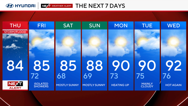
Thursday: NEXT Weather Alert Day for storms. High 84, Low 71
Friday: Isolated showers. High 85, Low 72
Saturday: Mostly sunny. High 85, Low 68
Sunday: PM showers. High 88, Low 69
Monday: Hot. High 90, Low 73
Tuesday: Hot. High 90, Low 75
Wednesday: Hot. High 92, Low 76
Get the latest weather info on the CBS News Philadelphia app.


