Freezing temps continue in Philadelphia region Monday, chance of snow this week. Here's the weather forecast.
The Philadelphia area officially broke its stretch of subfreezing temperatures Monday, but gusty winds are keeping conditions dangerously cold.
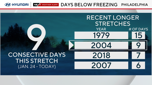
There have only been six times on record in our area where we have gone 10 days locked below 32, and there have only been two other times where there was a stretch longer than 10 days with freezing temperatures. One happened in February 1979, and the other in February 1961 — both were 15-day stretches.
If we don't go above freezing in Philadelphia on Tuesday or Wednesday, we may not get there for another week or more, so we could tie or break the 15-day record next weekend.
The normal high on Monday is 42 degrees, and there are no 40s in sight for at least the next 10 days.
NEXT big weather change
Along with this continuous and possibly record-setting stretch of cold days, we are looking at two chances of measurable snow this week.
Tuesday night into early Wednesday morning, a system just south of the area may lift far enough north to deliver a light dusting of snow, especially to areas south of Philadelphia. This would occur between midnight and 5 a.m. and be out completely by the bulk of the morning commute.

Then, on Friday evening into early Saturday morning, a clipper system dives out of Canada. It's still early, but light snow or snow showers are possible. The NEXT Weather team will continue to keep an eye on this system.
But compared to our storm last week, neither system looks impressive.
Here's your 7-day forecast:
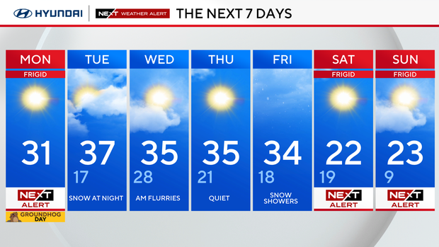
Monday: High 31.
Tuesday: Snow at night. High 37, low 17.
Wednesday: AM flurries. High 35, low 28.
Thursday: Quiet. High 35, low 21.
Friday: Snow showers. High 34, low 18.
Saturday: NEXT Weather Alert for Arctic blast. Frigid again. High 22, low 19.
Sunday: NEXT Weather Alert for Arctic blast. High 23, low 9.