Philadelphia weather: Enjoy the snow, but stay safe in bitter cold

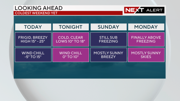
PHILADELPHIA (CBS) -- Saturday is another NEXT Weather Alert Day with strong breezes blowing snow as the Delaware Valley experiences its coldest weekend yet this winter season.
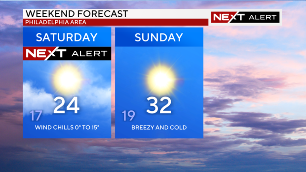
Saturday will experience a high of 24 degrees and low of 17 degrees with wind chills ranging from zero to 15 degrees. Across the region the highs will be in the low to mid 20s. Sunday will hit a high of 32 degrees and a low of 19 degrees continuing to be breezy and cold.
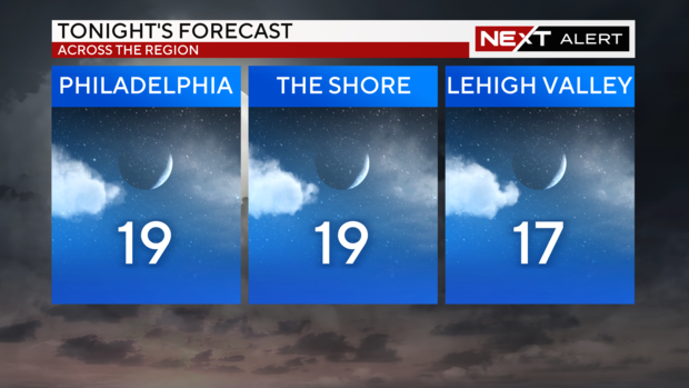
Saturday evening will be mostly cloudy and is expected to turn clear and very cold with a low of 19 degrees and a wind chill ranging from zero to 10 degrees. The shore can expect to see a low of 19 degrees as well and the Lehigh Valley will see a low of 17 degrees.
The gusty winds from the northwest will blow snow into Sunday.
Snow fall totals
Friday's snowstorm reached high snow totals across the region with some areas seeing up to seven inches of powder.
The National Weather Service data showed West Philadelphia got 5.9 inches of snow. The Philadelphia International Airport also saw major numbers with 4.6 inches of snow. It's safe to say the city of Philadelphia saw four to six inches of snow from Friday's storm.
Pennsylvania suburbs also saw an outpouring of snowfall.
- New Hope: 5.0 inches
- Malvern: 5.0 inches
- Chelsea: 5.5 Inches
- Royersford: 6.0 inches
- Plymouth Meeting: 5.5 inches
The Lehigh Valley didn't get nearly as much snow during this storm. Here's what spotters saw:
- Washington Township, Pa.: 3.0 inches
- Macungie: 2.8 inches
- Hellertown: 2.5 inches
- Kunkletown: 2.1 inches
- Reading Regional Airport: 3.5 inches
Delaware saw the most snow fall, turning Kent and New Castle counties into a winter wonderland.
- Dover: 7.0 inches
- Clayton: 6.0 inches
- Middletown: 6.0 inches
- Delaware City: 5.5 inches
- Bear: 5.5 inches
- Milford: 5.0 inches
Parts of New Jersey were also slammed with more than 5 inches, especially in Atlantic, Cumberland and Gloucester counties.
- Atlantic City: 6.0 inches
- Hopewell Township: 6.5 inches
- Mount Royal: 6.5 inches
- Medford Township: 6.1 inches
- Mount Laurel: 6.0 inches
- Blackwood: 5.8 inches
Looking forward, Sunday will be mostly sunny and breezy with blowing snow as well -- much like Saturday. The bitter chill will continue with a high of 32 degrees and wind chill ranging from 10 to 20 degrees.
Monday will be mostly sunny and the region will finally reach above-freezing temperatures with a daytime high of 36 degrees.
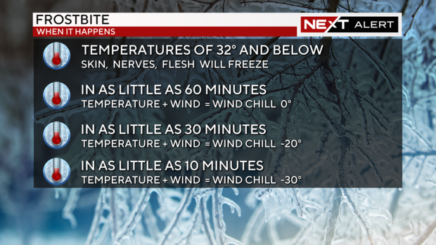
With the weekend continuing to experience frigid temperatures, frostbite should be a concern for residents of the Delaware Valley. If skin is not properly protected during the freezing weekend conditions skin, nerves and flesh are capable of freezing.
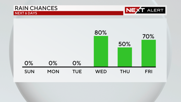
Looking forward, a series of storms will be coming through the region starting Tuesday. Clouds are expected to form Tuesday that will lead into the first sprinkles of rain on Wednesday. Thursday and Friday, however, will experience heavy rains.
Here's your 7-day forecast:
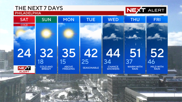
Saturday: High of 24 degrees.
Sunday: High of 32 degrees, low of 18 degrees.
Monday: High of 35 degrees, low of 15 degrees.
Tuesday: High of 42 degrees, low of 25 degrees.
Wednesday: High of 44 degrees, low of 34 degrees.
Thursday: High of 51 degrees, low of 37 degrees.
Friday: High of 52 degrees, low of 46 degrees.
Get the latest weather info on the CBS News Philadelphia app.


