Temps in Philadelphia region climb above freezing Wednesday as weekend snow forecast takes shape
Wednesday ushered in another frigid morning across the Philadelphia region with air temperatures in many locations outside the city plunging to the single digits and even sub-zero air temps in areas in the northwest.
The temperatures in Allentown this morning hit -9, which ties for the second coldest temp ever recorded in the city. The coldest ever was -15, which happened on this same date back in 1994.
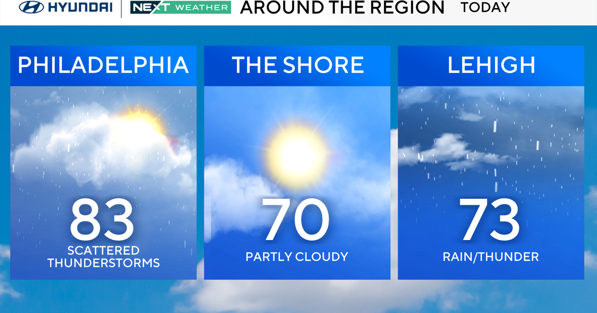
Today and tomorrow thaw out a bit with highs at least back above freezing and possibly near 50 tomorrow, but then we prepare for brutal Arctic cold and what could be the biggest snowstorm in a decade.
NEXT big weather change
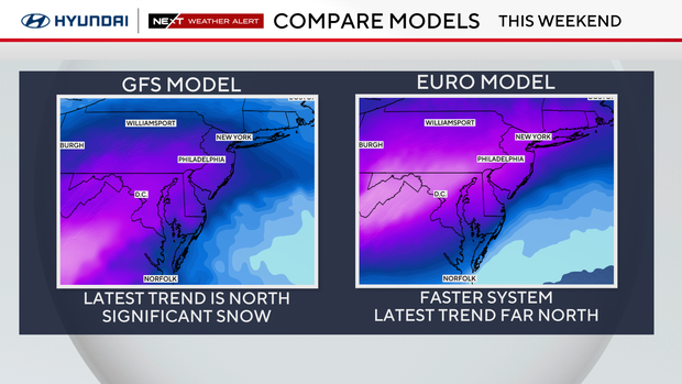
OK, picking up where we left off Tuesday. Let's lead with the fact that all our computer models have come into agreement about at least one thing: that a snowstorm will happen here.
The GFS, which was the lone southern outlier yesterday, has come on board and now forecasts a classic nor'easter setup. The EURO and Canadian have gone even farther north with the track, which the NEXT Weather team suspects will correct back south.
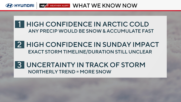
Here's what we know:
- A fresh infusion of Arctic cold will arrive Saturday, with highs only in the teens and overnight lows in the single digits
- An area of low pressure coming onshore in California today will develop near the Gulf of Mexico, move through the Deep South and exit off the East Coast Sunday, potentially into Monday. This will allow it to draw in lots of moisture from the Gulf and Atlantic
- Any precipitation that falls in the Philadelphia area will fall as snow with temperatures no better than the teens
- Sunday will be the day most impacted
The disturbance that will develop into this storm moves over land today. This will allow us to better sample and run more accurate models. The NEXT Weather team would like to see higher-resolution short-range models come into range with this system, as they sometimes will pick up on nuances that the long-range models miss.
Most notably and still at the forefront of our memory was the storm in 2015 that was impacted by an inverted trough that was only really picked up on by the mesoscale models.
The latest Euro runs have indicated some mixing/sleet potential along the coast and even try to inject a little warm layer aloft near the city. With the arctic cold in place, this seems unlikely, but it's another trend to watch.
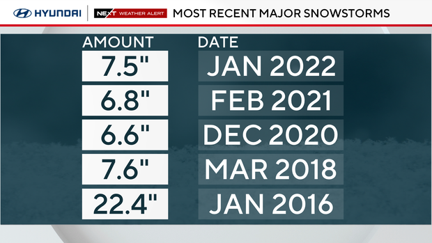
It's too early to put out totals, but it's looking likely that we get at a minimum of 6 inches of snow from this system, if not a foot or more. This is impactful because we haven't even had a snowstorm with more than 8 inches since 2016, when we picked up our annual average snowfall of 22.4 inches in one storm.
Impacts will include major disruptions to travel Sunday into Monday, likely school closures Monday and dangerous cold accompanying the storm that could put lives at risk. We are watching every nuance of this storm as it develops and will communicate any changes as soon as we get them.
Where to find warming centers around Philadelphia
Philadelphia has activated an Enhanced Code Blue due to the extremely cold temperatures. The city activates an "enhanced" alert when a Code Blue lasts more than three nights in a row.
Because of the enhanced alert, the Office of Emergency Management has opened multiple warming centers throughout the city. The centers are free and open to the public.
People who need help or see someone in need of help during this cold weather event can also call 215-232-1984.
Bucks County issues a Code Blue whenever temperatures drop below 20 degrees, but could also issue the alert based on other cold-weather factors.
Information about shelter openings can be found on the Housing Link website.
Residents who need temporary shelter, food and clothing during the winter can call 211 or text their zip code to 898-211 for immediate assistance.
During a Code Blue, residents in need of shelter are encouraged to visit one of Delaware County's weather advisory relief centers.
During a Code Blue, the county has additional resources for people experiencing homelessness, including access to temporary warming shelters, food and clothing.
Anyone who needs help with temporary shelter during the cold can call the Your Way Home Call Center at 610-278-3522.
New Jersey
Active Code Blue declarations are listed by county on New Jersey 211's website. The site also includes a list of available warming centers in each county.
Delaware
The Delaware Department of Health and Social Services has opened eight warming centers across the state through Jan. 21. A list of warming centers in each county and their addresses is posted online.
Here's your 7-day forecast:
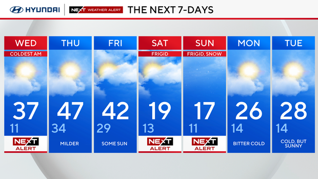
Wednesday: High 37, Low 11
Thursday: Milder. High 47, Low 34
Friday: Some sun. High 42, Low 29
Saturday: NEXT Weather Alert frigid temps. High 19, Low 13
Sunday: NEXT Weather Alert for frigid, snow. High 17, Low 11
Monday: Bitter cold. High 26, Low 14
Tuesday: Cold but sunny. High 28, Low 14