Wednesday in Philadelphia region set to be hottest day of heat wave. Here's the weather forecast.
Wednesday in the Philadelphia region will likely be the hottest day of the heat wave, with high temps pushing the 100-degree mark across most of the area, including the Jersey Shore.
It's a must to stay cool, as heat-related illnesses will be easy to get if you are not taking precautions. Drink plenty of water, wear lightweight, light colored clothing, and check on your neighbors, especially those who don't have a working air conditioner.
We could also see a few pop-up storms during the evening, but they will not be widespread. If you do happen to get underneath one, you'll have heavy rain, lightning and the possible gusty wind threat to deal with. The timing on that is roughly between 6 and 11 p.m.
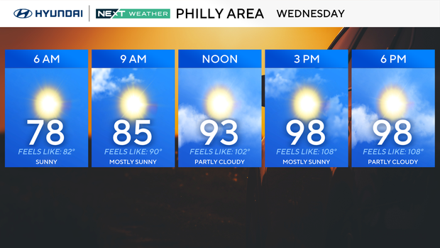
A NEXT Weather Alert has been issued for Wednesday's heat, as this is the day we could experience dangerous heat index values in the 105-110 range. The heat will continue into the weekend as well.
NEXT big weather changes
A weak cold front will pass through Thursday morning, with a spotty shower or two. This should limit the temperatures slightly and will bring a reduction in humidity for Friday, even though the heat wave will continue.
Another front approaches for the weekend.
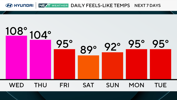
Ahead of it will likely set off some strong storms as the heat breaks down. We'll monitor this timeframe for a possible NEXT Weather Alert for severe storms on Saturday. At this point, we are not under an official risk assessment from the Storm Prediction Center but it's worth monitoring. Both Saturday and Sunday have the potential for storms but it will be cooler on Sunday.
We're back to more seasonable temperatures to start next week.
Here's your 7-day forecast:
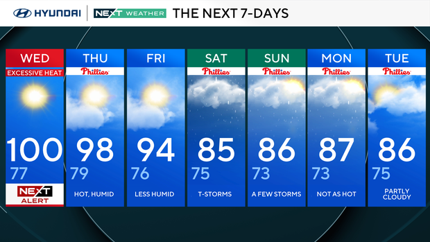
Wednesday: NEXT Weather Alert for excessive heat. High 100, low 77.
Thursday: Hot and humid. High 98, low 79.
Friday: Less humid. High 94, low 76.
Saturday: Thunderstorms. High 85, low 75.
Sunday: A few storms. High 86, low 73.
Monday: Not as hot. High 87, low 73.
Tuesday: Partly cloudy. High 86, low 75.


