Cool, fall Sunday with partly sunny skies in the Philadelphia area. Here's the weather forecast.
High pressure remains in control as we head through the second half of the weekend, which means crisp sunshine through the morning with temperatures in the 40s and 50s. Temperatures will eventually warm to near 60 degrees with a few more clouds developing through the afternoon into the evening.
Sunday night will be very similar to the last couple of nights. The afternoon and evening clouds will gradually clear out, allowing temperatures to cool more efficiently and eventually settle in the mid-upper 30s in more locations. Temperatures will be a little warmer along the I-95 corridor, but still pretty chilly with lows in the low-middle 40s. Areas of frost will certainly be possible once again early Monday morning.
By early this week, the weather pattern will become more active. Low pressure develops off the Carolinas on Monday and tracks out to sea, followed by another system forming off the southern Mid-Atlantic Tuesday into Wednesday. This second storm could move north along the coast on Thursday, bringing gusty onshore winds, rain and coastal flooding concerns, especially for shore and back bay communities already affected by earlier storms. Conditions will remain chilly through the end of the week before high pressure returns Friday into the weekend.
Halloween forecast preview
There remains a fair amount of uncertainty in how the storm system on Thursday will develop and track. The details of its evolution will ultimately determine the exact impacts and when the system eventually departs. That said, right now it looks like rain may linger into Friday morning but hopefully starting to clear out for trick-or-treating Friday evening.
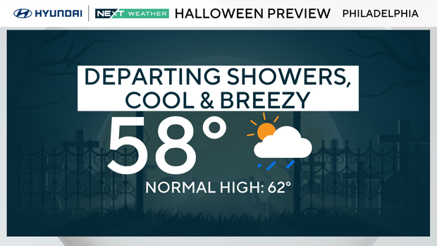
It is worth noting that while Thursday will be the rainiest day, this system will NOT be anything like the coastal storm we were tracking two weeks ago.
Tracking Hurricane Melissa's path
Meanwhile, Hurricane Melissa is a Category 4 hurricane and continues to strengthen south of Jamaica with winds now near 140 mph. The storm is expected to become a Category 5 storm later Sunday, posing a catastrophic threat of flooding and landslides for Jamaica and southern Hispaniola.
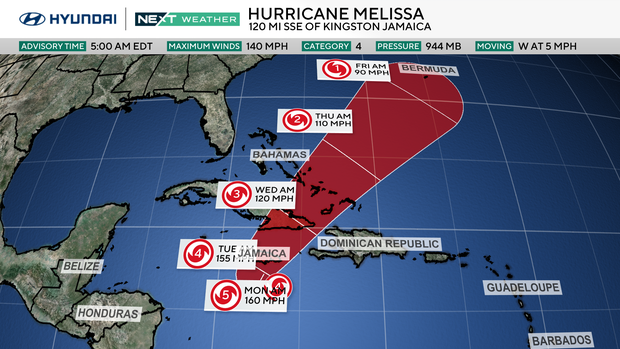
Storm surge up to 13 feet and rainfall totals of 15 to 30 inches are possible in those areas through midweek. The system will turn north early next week, potentially nearing eastern Cuba by Tuesday or Wednesday.
No direct impacts are expected from Melissa on the mainland of the United States.
Here's your 7-day forecast:
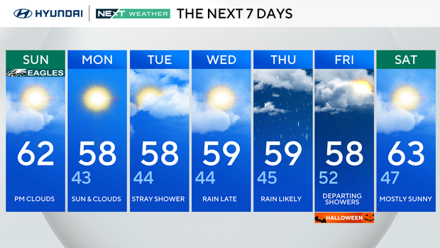
Sunday: P.M. clouds. High 62, Low 43.
Monday: Sun & clouds. High 58, Low 43.
Tuesday: Stray shower. High 58, Low 44.
Wednesday: Rain late. High 59, Low of 44.
Thursday: Rain likely. High 59, Low 45.
Friday: Departing showers. High 58, Low 52.
Saturday: Mostly sunny. High 63, Low 47.