Sunny and breezy Christmas Eve in Philadelphia area, tracking precipitation later this week. Here's the forecast.

If you're hitting the road this morning you can expect a sunny and breezy conditions. However, we are tracking some precipitation that is expected to move in later this week.
Planning your holiday
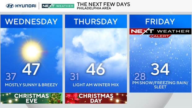
Christmas Eve will feature plenty of sunshine with highs in the mid-upper 40s, but the winds will be much stronger, making it feel cooler. Gusts could reach 30 mph, which will make it feel more like the upper 30s through Wednesday afternoon.
NEXT big weather change
A fast-moving system will bring a small chance for some light winter mix on Christmas morning, but the second half of Christmas should be dry with high temperatures in the middle 40s.
Attention then turns to Friday, when a stronger system will likely impact the region. Current trends suggest a period of wintry precipitation is possible, especially north and west of I-95, with a gradual change to rain farther south. Cold air ahead of a storm system tracking across the Midwest will set the stage for the chance of snow and even some freezing rain from late Friday afternoon through early Saturday morning.
There remains some uncertainty in how the system will take shape, but it's looking more likely that our area will have some impacts as many people have travel plans to wrap up the Christmas week. The best advice if you have any travel plans: Leave early on Friday or late on Saturday to avoid any potential winter mess.
Following that, we're tracking another system on Sunday night that will likely bring rain showers to the region, followed by a windy and bitterly cold start to the final week of 2025.
Here's your 7-day forecast:
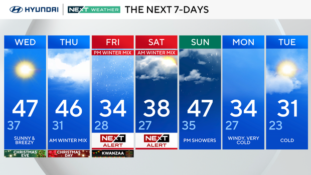
Wednesday/Christmas Eve: Sunny and breezy. High 50, low 39.
Thursday/Christmas Day: Morning winter mix. High 47, low 33.
Friday/Kwanzaa: NEXT Weather Alert for evening winter mix. High 44, low 38.
Saturday: NEXT Weather Alert for morning winter mix. High 47, low 40.
Sunday: Evening showers. High 46, low 40.
Monday: Windy, very cold. High 34, low 27.
Tuesday: Cold. High 31, low 23.