Winter of 2023-24 in New York City to go down as fourth warmest, dating back to the 1800s

NEW YORK -- With the official start of spring, known as astronomical spring, now underway, meteorological winter, defined as the months of December, January, and February, was another one for the record books in New York City.
Meteorologists measure the seasons in three-month intervals, simply because it's easier to track the data within them. Each of the months that encompass winter featured temperatures that were well above average, with December 2023 ranking as the 2nd warmest December ever. That led to the winter of 2023-2024 finishing as the fourth warmest winter ever, and that's on the heels of the winter of 2022-2023 coming in at second place. Overall, it was the warmest winter ever for the contiguous United States as a whole. February 2024 was also the warmest across the planet and the ninth consecutive month of record warmth globally.

Our cold streak keeps getting shorter, according to Climate Central. The nonprofit crunches climate data starting from 1970.
"You now experience 15 more days above average during the winter in New York City. Your cold snaps are shrinking by the order of about seven days," Meteorologist Lauren Casey told CBS New York's Vanessa Murdock.
According to Climate Central, the city's coldest temperatures also measure nearly five degrees warmer than five decades ago.

Part of the reason why our temperatures were skewed so much above average this past winter was not so much due to daytime high temperatures getting that high, but from overnight low temperatures not getting that low. Many nights saw lows that were well above freezing, with only 36 dates that observed temperatures at or below freezing. The average number of days is 71. Although there were a few cold days here and there, extreme cold was largely absent, as the lowest temperature observed this winter was only 17 degrees. In comparison, the lowest low during the previous winter was 3 degrees.

This past winter was filled with numerous storms that delivered copious amounts of rain, but not much snow throughout the area. The succession and intensity of these storms led to severe flooding, especially across the river basins of northern New Jersey. It turned out to be our 15th wettest winter ever with an impressive total of 14.04 inches, which includes rain and melted snow. Consequently, the clouds and moisture associated with the abundance of storms had a hand in keeping temperatures elevated, most notably at night.

In terms of snow, once again it was another lack luster season, with only 7.5 inches of snowfall, which ranks as the ninth least snowy winter. That follows the least snowy year on record, which was set just last year when only 2.3 inches of snow fell in the park. Yet another record was achieved this past winter, and that was for longest stretch of days without an inch or more of snow falling in one day. It took 701 days from Feb. 6, 2022 to Jan. 16, 2024 for more than an inch of snow to fall (1.3" to be exact) to end the snowless streak. This completely obliterated the previous streak of 383 days that stretched from March 3, 1997 to March 22, 1998.
Why has it been so wet and mild?

Given such a wet and warm pattern, many people might be wondering what the culprit is. Besides the effects of anthropogenic induced global warming, the answer is simple: El Niño. This phenomenon, characterized by the warming of the equatorial Pacific Ocean, occurs every two-to-five years and can have far reaching global effects. In our region, El Niño typically plays out in the form of warmer temperatures and above average precipitation, and that is exactly what transpired this winter season.

During an El Niño event, the northern branch of the Jetstream, also known as the polar jet, is pushed to the north and is not as strong, thus preventing arctic air from entering the region. On the flip side, the southern branch of the Jetstream, also known as the subtropical jet, becomes invigorated and is able to travel farther north than usual, thus funneling more moisture from the tropics in with it.

The outcome of this El Niño winter was nearly a textbook example, however, this isn't always the case. The winter of 2009-2010 also featured El Niño but, unlike this one, saw more phasing of the polar and subtropical jet streams. The end result was a blockbuster snow season in which more than 50 inches fell. El Niño's effects are greatest and peak during winter but can also influence weather in the seasons preceding and succeeding it.
How does Spring 2024 look?
Astronomical spring may have just started, but meteorological spring began on March 1st. So far, it's been off to a very warm start, continuing the trend of the winter. The winter and early spring warmth have had major implications on the local flora. Many trees have been budding, and flowering bulbs have been blooming, as well. In many cases, this was observed in late February, more than a month earlier than the normal period of early April.
"The warmth we've had, particularly in the last couple of weeks, is a little worrisome," said Dr. Dave Robinson, New Jersey state climatologist at Rutgers University. "If we get a hard freeze, the plants are one, two weeks ahead of schedule, and that puts them in the danger zone."
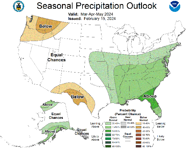
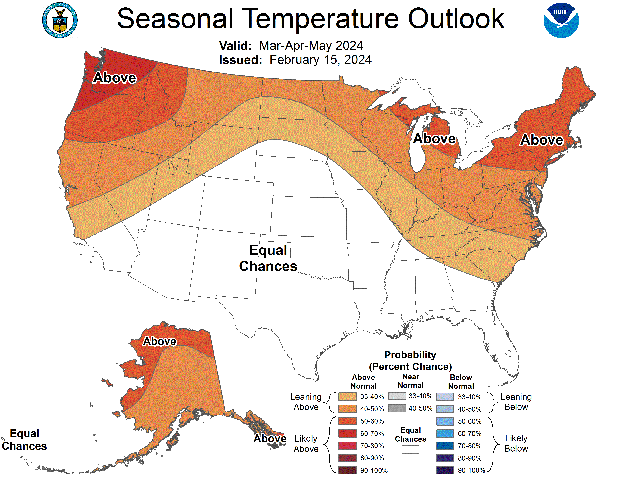
While snow and freezing temperatures can occur well into April, the likelihood of them occurring this spring is low. Most forecast models suggest that both the above average temperature and precipitation trend will continue through the month of May, indicating that the effects of El Niño will linger a while longer.


