How much snow will NYC, New Jersey, Connecticut and Long Island get this weekend?
The year 2023 ended on a warm note. While this past year was filled with extremes and all types of records being broken across our area, the most noteworthy was the consistent warmth.

Not only was December super mild, now ranked as the second warmest December ever recorded, but 2023 is now ranked as the warmest year ever recorded in Central Park.

The year was also extremely wet, with 2023 ending as the 11th wettest year ever recorded.

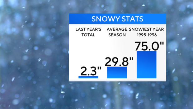
All that moisture did not lead to much snow however, as only 2.3 inches fell throughout the entire year. That made 2023 the least snowy calendar year ever.
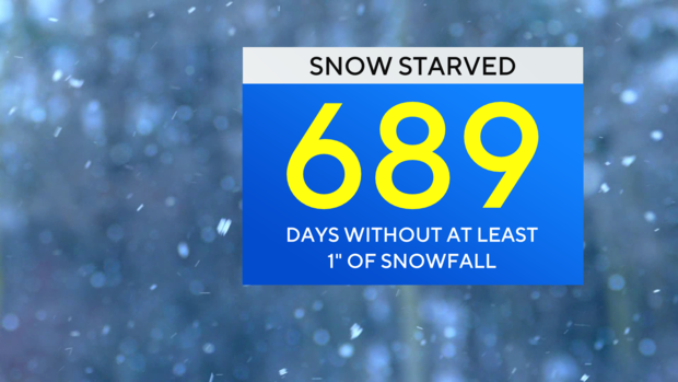
To further add to the dismay of snow lovers, it has been nearly 700 days since more than an inch of snow fell in the park. And yes, that's record-breaking too.
Will 2024 continue this snowless trend?
In the short term, it is looking more likely that we may finally end this prolonged snow drought.

Nearly all forecast models are suggesting that a significant winter storm will move into the Tri-State Area from late Saturday into Sunday. With origins in the Southwest, the storm will be able to gather moisture from the Gulf of Mexico, plus dynamic energy and cold air from the north. In other words, this would be a scenario when the northern branch of the jet stream and southern branch of the jet stream combine, a term meteorologists call "phasing". When phasing occurs over our region, it can lead to blockbuster snowstorms. Phasing over our area happens to be very common in winters that feature the phenomenon none as El Nino, which we are currently in.
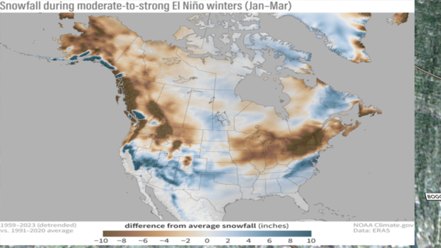
For example, the infamous El Nino winter of 2009-2010 produced 51.4 inches of snow in the park. 36.9 of those inches fell in February 2010, and that month holds the record for snowiest month ever recorded. In an average winter, 29.8 inches typically falls.

Latest First Alert Weather data on how much snow we'll see this time
Of course, things will shift in the next 48 hours as data continues to fine-tune, but it's looking like a mix of rain and coastal winds with a healthy amount of mixed precipitation and a heavy, wet snow in our suburbs.

As of 6 p.m. Wednesday, the GFS model updated with about 5.5" of snow in Central Park, while the EURO is still at 1.1"
These models have been fluctuating quite a bit, but given the latest track, it would track too close to the coast, and the biggest snow would therefore push north & east of our area into New England with the highest totals. Given the cold air will slightly erode Saturday, this seems plausible.

The GFS model has taken it farther east, and you can see the numbers are overall bigger, yes, but not bonkers. We don't see 12-18" (YET). The contouring is more even and spread-out, but it still has little to no snow down the NJ shore.

Experience has shown us that cold air is the key for local snowfall events during the middle of the season. The storms must track far enough offshore to pull in a north or northeast wind. Then we really get some big numbers. If the track continues to hug the coast, we will no doubt pull in rain and stronger winds. You would have a large variety of weather across a relatively short distance.
A strong east wind will move the water. We could see some minor coastal flooding, especially at high tides.

When it wraps up Sunday is still up for debate, but it looks like Sunday afternoon (EURO) to possibly lingering as late as 1 a.m. Monday according to the latest GFS.
At this point, we're thinking we will see a good amount of mixing, which is why we have T-2" instead of 6"+ in the city. The Bronx could see a little more, as history would dictate the 1-95 corridor is yet again in the battle zone where sleet, snow, and rain come to fight. That will kill your big scary NYC snowfall numbers. The quality of the snow looks wet & heavy too; It's a "milder" storm as we don't have polar air in place.

We have seen this scenario before....Sullivan County, Sussex County, Ulster and Dutchess will look like a winter wonderland. Morris County & Passaic see decent snowfall, and a messy mix of big flakes, sleet and rain as you approach NYC and areas south. A similar story on Long Island with a variety of modest snowfall, sleet and rain.
Again, expect some changes. As we get closer to the event, we will have a better idea of who gets what & how much. We have a few days, it's only Wednesday and it's tracking over land. This helps us forecast.
What's next?
We have issued a Yellow Alert for Tuesday for another storm, but this time consensus is all rain with warmer temps in the 50s. This storm could start off as snow north & west, before turning to all rain. This could cause some unique challenges as warm water over a snowpack AND a saturated ground.


