Updated weekend snowfall forecast for NYC, New Jersey, Long Island and Connecticut from the First Alert Weather Team
NEW YORK -- For snow lovers across the Tri-State Area, it's been a difficult last several years.
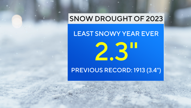
Not only was 2023 the least snowy calendar year ever recorded, but last winter was also the least snowy.
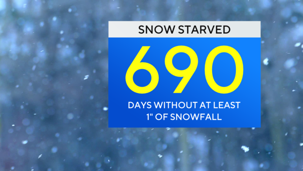
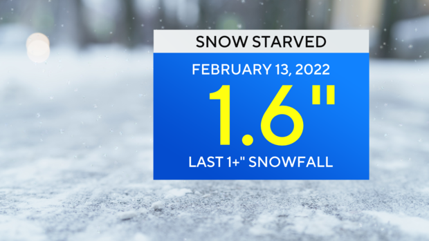
Only 2.3 inches fell during the winter of 2022-23, and it has been nearly 700 days since more than an inch of snow fell in Central Park, which is also record-breaking.
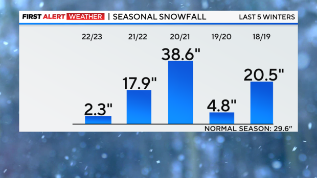
In fact, for much of the last five years, getting average or above-average snowfall has been hard to achieve.
The only exception was the winter of 2020-21, when nearly 40 inches fell. In an average winter, 29.8 inches typically falls.
Could we finally break the streak this weekend?
Although not a blockbuster, it is very evident that a significant winter storm will move into the Tri-State area from Saturday afternoon into Sunday.
As of now, the odds of New York City seeing a significant snowfall this weekend have come down considerably. Earlier in the week, it was looking very likely that we would break our snowless streak. However, in order to get a healthy snowfall in the city, certain factors have to all come together at once. That simply is not the case this go-around. These include a well-defined cold airmass at the start of the storm, and a storm track far enough offshore to prevent milder ocean air from mixing in.
The latest data
The forecast for this storm has been particularly challenging. Nearly every forecast model has been predicting varying amounts of snow and differing on the storm track. It does now appear that at least some parts of the New York Metropolitan region may double or even triple the amount of snow they saw for all of last winter. This would be fairly easy to achieve though, given last year's such paltry numbers.
Factors contributing to the uncertainty among the models are the lack of very cold air in place at the beginning of the storm and nearby ocean temperatures are still running above average. This affects where the rain/snow line sets up along the coast, and ultimately governs how much snow falls.
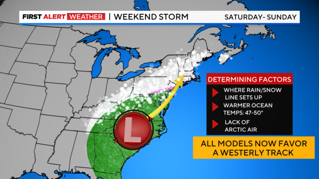
A firmly entrenched cold airmass at the start of the storm would ensure an all-snow event, and colder ocean temperatures would limit mixed precipitation and rainfall from getting into the mix. Nailing exactly where that rain/snow line sets up is essential to knowing who gets the most snow.
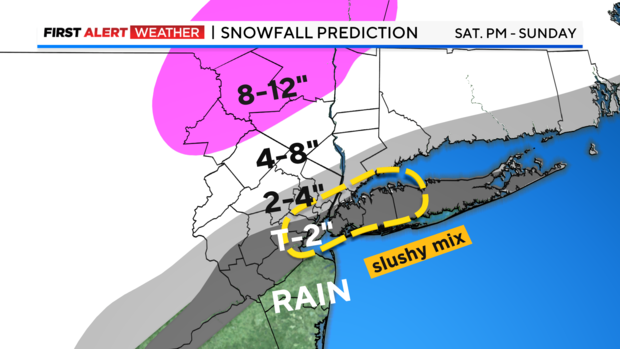
To the dismay of snow lovers, the latest track of the storm has it parallelling the coastline and places the rain/snow line just to the north of the city. In this setup, the storm will be able to draw milder air in from the ocean and erode the minimal amount of cold air already in place. This would produce minimal snow at the coast, but much higher totals, possibly near a foot or more, for the higher elevations to the north and west of the city.
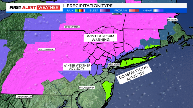
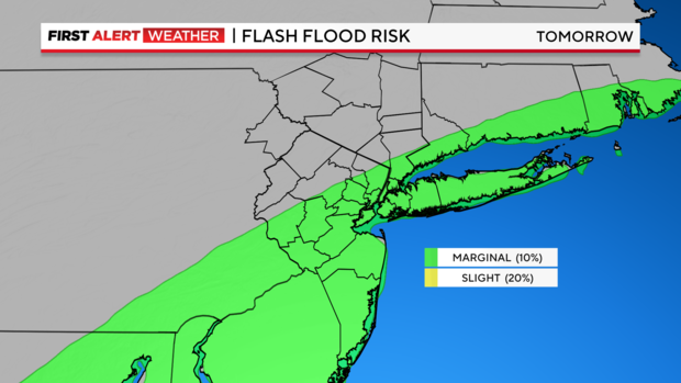
Mainly rain and mixed precipitation are depicted for areas south and east of the city. Due to recent storms dropping hefty amounts of rain in recent weeks, the threat of localized flooding is elevated.
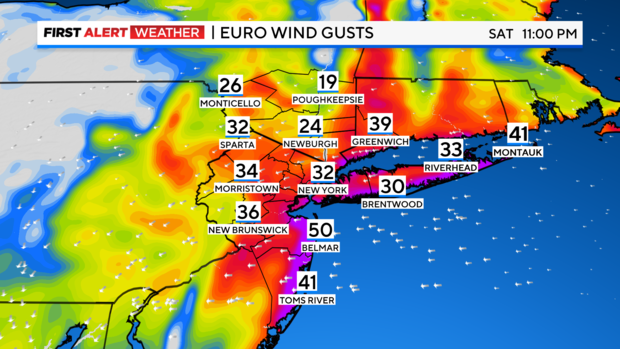
Because this is a coastal storm, hazardous conditions associated with coastal storms, such as high winds and coastal flooding are to be anticipated as well. Wind gusts may reach near 50 mph at the immediate coast.
For areas that do see accumulating snow, it will be a very heavy, wet snow, given the marginal amount of cold air associated with this system. This is perfect for making a snowman, but potentially dangerous for individuals that are out of shape and decide to shovel.
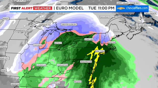
Once this storm departs, there will be another one right behind it. That storm looks to be an all-rain event by the time it reaches our region on Tuesday into Wednesday. It will be very strong and will have the capacity to produce damaging winds and flooding rains. Those rains on top of a snowpack and already saturated ground could lead to widespread flooding. Because of this, we are already issued a Red Alert for that timeframe and will carefully monitor the situation.
Breaking the storm down by region
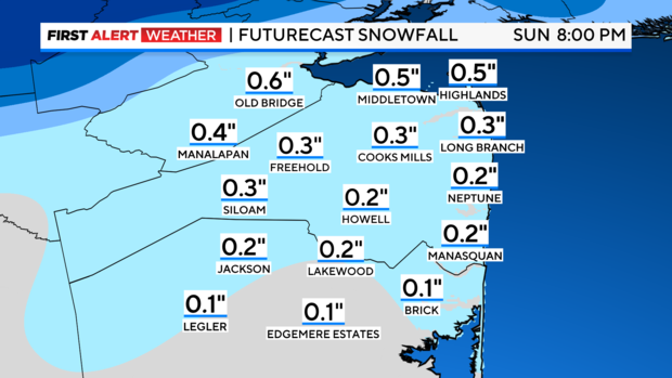
- Jersey Shore and Central New Jersey
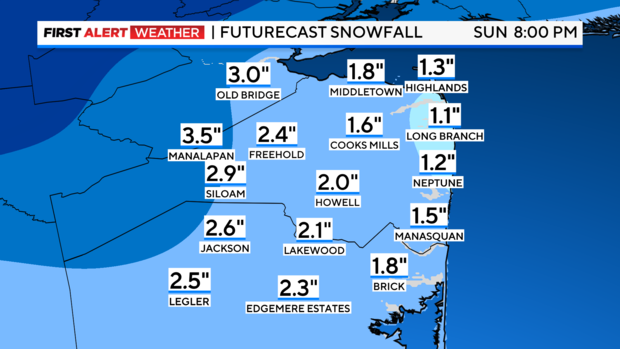
Rain or mixed precipitation to start, changing to all rain, then changing to all snow as the storm departs. Final totals: .75-1 inch of rain, coating - 1 inch of snow. Wind gusts up to 50 mph. Coastal flooding and high surf may lead to beach erosion.
- Long Island
Rain or mixed precipitation to start, changing to a mix of rain and snow, then changing to all snow as the storm departs. Final totals: .5-1 inch of rain, coating to 1 inch of snow. Wind gusts up to 50 mph. Coastal flooding and high surf may lead to beach erosion.
- NYC
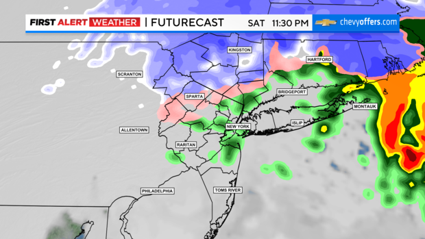
Snow or mixed precipitation to start, changing to a mix of rain and snow, then possibly all rain for a while, before changing to all snow as the storm departs. Final totals: .5-1 inch of rain, coating-2 inches of snow. The Bronx may see higher snow totals. Wind gusts up to 35 mph.
- Hudson Valley, Northern New Jersey
This is where the highest snow totals are expected. In other words, the "Jackpot". Here, little to no mixing with rain is anticipated. Snow may be heavy at times, amounting from 4-8 inches, with certain spots possibly reaching up to a foot or more. Wind gusts up to 35 mph.
- Coastal Connecticut
Snow to start, changing to a wintry mix, then ending as snow. 2-3 inches of snow is likely. Wind gusts up to 40 mph, with some minor coastal flooding.


