As excitement builds for possible return of snow, a look at how much snow NYC might get this winter

NEW YORK - Last year was the least snowy winter on record for the Tri-State Area, but with a storm on tap for the weekend, the numbers could change for 2024.
Snow may finally fall again this weekend, to the delight of some.
"I can't wait for the snow to come," Rolando Smith of Teaneck said.
"If it was during the holidays I would have been excited. But now that the holidays are over, I don't want to have to clean my car. It's a headache," Edgewater resident Mike Khoury said.
"It hasn't snowed in so long. I'm excited that it might actually happen," Lisa Hantman of West New York said.
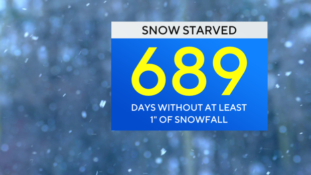
It has been 689 days and counting without an inch or more falling in Central Park.
Dr. Dave Robinson, New Jersey State Climatologist at Rutgers University, said El Nino is the big driver of this season's snowfall forecast.
"I look at this El Nino winter... as a feast or famine winter for snow,' he said.
During El Nino, warm water builds in the equatorial pacific and impacts weather patterns in the U.S.
"Climatologically, when you look at El Nino winters from South Jersey into the Mid-Atlantic, you tend to have above-average snowfall," Robinson said. "From Central Jersey, New York-metro north, especially interior New England, you get lower snow than normal."
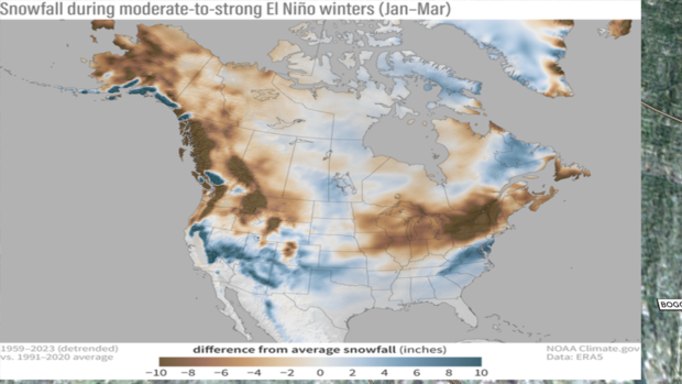
El Nino storm tracks favor rolling up the coastline, bringing big potential for snow, but only if cold air pairs with the storm's arrival.
"There are some El Nino winters you can't make the match," Robinson said.
But when you do, record-setting snowfall may pile up. That happened in 2016, another big El Nino winter when 27.5 inches of snow buried the city in January, and took the record for biggest snowfall on record.
"I think MLK Weekend really is the start of winter," Judah Cohen, director of seasonal forecasting at Verisk, said.
He blamed climate change.
"We've seen a very strong decrease in severe winter weather events in the month of December. Strongest warming trend of all winter months," Cohen said.
He said to get snow, we need the polar vortex, an area of low pressure that lives at the North Pole, to weaken and allow cold air to spill our way.
"And the polar vortex only really gets started... in January," he said.
Cohen has high hopes for the second half of the month.
"If you're a snow lover, this is about as good as it gets," he said.
Cohen said the vortex will weaken, cold air will be in place, and the atmosphere, like a chess board, has its pawns perfectly positioned to churn out snow.
So what is the model projecting total snowfall for New York City?
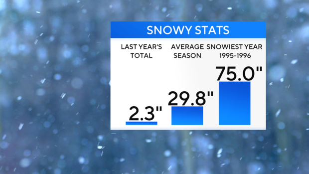
"Twenty five point six inches," Cohen said.
That's not far off our average of 29.8 inches, and likely delivered by just a few good storms.
Robinson adds North American snow cover in December ranked third lowest in more than 50 years.


